San Roque West, La Union
| San Roque West, Agoo, La Union | ||
|---|---|---|
| Barangay | ||
| ||
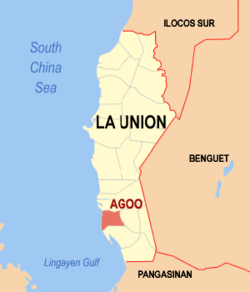 Map of La Union showing the location of San Roque West, Agoo. | ||
.svg.png) San Roque West, Agoo, La Union Location in the Philippines | ||
| Coordinates: 16°17′18″N 120°21′20″E / 16.28833°N 120.35556°ECoordinates: 16°17′18″N 120°21′20″E / 16.28833°N 120.35556°E | ||
| Country |
| |
| Region | Ilocos Region (Region I) | |
| Province | La Union | |
| Congressional District | 2nd District | |
| Municipality | Agoo | |
| Barangay | San Roque West | |
| Sitios | 4 | |
| Government | ||
| • Mayor | Dr. Sandra Y. Eriguel | |
| Time zone | UTC+8 (PST) | |
| ZIP code | 2504 | |
| Dialing code | +63 | |
| Religions |
Roman Catholicism Born Again Iglesia ni Kristo Protestantism | |
| Feast | Easter Sunday | |

| Population Census of San Roque West | ||
|---|---|---|
| Year | Pop. | ±% p.a. |
| 1990 | 926 | — |
| 1995 | 956 | +0.60% |
| 2000 | 1,136 | +3.77% |
| 2007 | 1,207 | +0.84% |
| 2010 | 1,438 | +6.58% |
| 2015 | 1,455 | +0.22% |
San Roque West is a rural barangay in municipality of Agoo, La Union, Philippines. According to the latest census, it has a population of 1,455 (2015)[1] Majority of its population, Pangasinense is the language spoken making it as the only barangay in Agoo, La Union with official Pangasinense as language. Ilocano is also language spoken while English and Filipino are the medium of instruction in the schools.
History
Agoo was formerly part of Mangaldan, Pangasinan, which predominantly Pangasinense speaking area. Thru initiative of former Congressman Aspiras, which also he became tourism secretary of former President Ferdinand Marcos. To enhance the internal revenue allotment of Agoo they form the additional barangay of Agoo from original 14 to 49, which San Roque West was established since 1978 and formerly part of Brgy. San Joaquin, which later the school there renamed it to San Joaquin Elementary School. [2]
Its name San Roque is derived from its patron Saint Roque (Spanish and Filipino) also known Saint Roch, when Franciscans and Augustinians brought Roman Catholicism in Agoo since 1578.
Politically divided into two, the western part dominantly Pangasinense speaking became San Roque West and the eastern part dominantly Ilokano became San Roque East.
The prominent place in this barangay is called "Carpog", located at southwest portion of barangay, between Sitio Cruz and Ayaban near at Capengpeng Marsh, but since the 1990 Luzon earthquaked the area now are relatively at below sea level making it uneasy to live due to absence of potable fresh water, and the presence of salt water connected by Capengpeng Marsh and river to the Lingayen Gulf which droven the other residence transferred to Sito Cruz and Ayaban, due to small population and household around 7 it is now part of Sitio Ayaban.
Geography
San Roque West is situated about 4 kilometers (2.48 mi.) southwest of Poblacion of Agoo. It is located between 120° 20', and 120° 21' E. longitude and 16° 17' and 16° 18' N. latitude.

Its boundaries are formed by the barangay of Purok and San Isidro to the north, Balaoc, Santo Tomas, La Union and Capengpeng Marsh to the south, San Roque East to the east, and San Manuel Sur and Norte to the west.
The barangay is entirely a rural area, mostly coastal plain in northwest area and flood plain in southeast area of barangay, the northwest area are arable land and pasture land which suitable for agriculture, in arable land cultivating crops like rice, corn, peanuts and sweet potatoes "kamote", making it the product of this barangay in agriculture, while in pasture land it is the grazing area for domesticated livestock like carabao, goat, cattle, and swine.
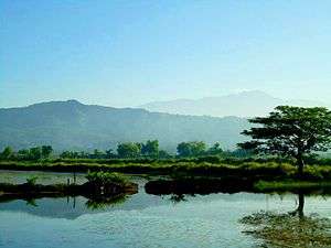
The floodplain in southeast area is mainly used for aquaculture. The fish ponds are dominantly located in Sitio Ayaban, Banaoang and Cruz. The presence of Capengpeng Marsh and a little river in this area irrigated the fish ponds with salt water, which is suitable for fish and crustaceans to grow like giant tiger prawn(sugpo in Filipino, "paddaw" in Ilocano and "paraw" or "binalo" in Pangasinense), shrimps, milkfish, tilapia, crabs and others. Fish ponds provide a source of food and income in this given area.
Sitios
San Roque West is politically subdivided into 4 sitios.
Fast Fact
Elected OfficialsBarangay Officials 2018
Barangay Officials 2013
Barangay Officials 2010
Barangay Officials 2007
Barangay Officials 2002
Barangay Officials 1997
Barangay Officials 1994
DevelopmentThru initiative of incumbent Gov. Manoling Ortega and Brgy. Capt. Wilfredo Estacio the creation of water tank made of concrete, stone and steel, driven by electric motor located at Brgy. San Julian West via Brgy. Purok was open last 2011. The presence of this water supply made the residence of San Roque West accessible to potable water. Gallery
|
References
- "https://www.census.gov.ph/data/census2007". census.gov.ph. Archived from the original on 2012-07-16. Retrieved 2012-01-11. External link in
|title=(help)
External links
- www.census.gov.ph/data/census2007/index.html
- www.nscb.gov.ph
- Agoo, La Union
- 1990 Luzon earthquake
- [Census of Population (2015). "Region I (Ilocos Region)". Total Population by Province, City, Municipality and Barangay. PSA. Retrieved 20 June 2016]
- Philippine Census Information