San Rafael Pie de la Cuesta
| San Rafael Pie de la Cuesta | |
|---|---|
 Municipal offices of San Rafael Pie de la Cuesta | |
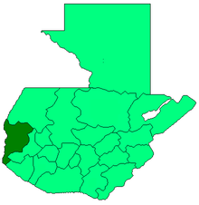
 San Rafael Pie de la Cuesta Location in Guatemala | |
| Coordinates: 14°56′00″N 91°55′00″W / 14.93333°N 91.91667°W | |
| Country |
|
| Department | San Marcos Department |
| Government | |
| • Mayor | Carlos Mazariegos[1] (LIDER) |
San Rafael Pie de la Cuesta (Spanish pronunciation: [san rafaˈel pje ðe la ˈkwesta]) is a municipality in the San Marcos department of Guatemala.
A small town with red tiled roofs and abundant flowering trees in the northern department of San Marcos, Guatemala, a department which borders Mexico. Although part of San Marcos is "cold country", the term used by Guatemalans to refer to the highlands which, while not cold, are certainly not as warm as the coastal plain, San Rafael Pie de la Cuesta is warmer than the rest of the department. As its name implies, San Rafael Pie de la Cuesta lies at the base of the Sierra Madre mountain range. There are many coffee plantations in the area.
Climate
San Rafael Pie de la Cuesta has tropical climate (Köppen: Am).
| Climate data for San Rafael Pie de la Cuesta | |||||||||||||
|---|---|---|---|---|---|---|---|---|---|---|---|---|---|
| Month | Jan | Feb | Mar | Apr | May | Jun | Jul | Aug | Sep | Oct | Nov | Dec | Year |
| Average high °C (°F) | 28.5 (83.3) |
28.8 (83.8) |
30.0 (86) |
30.1 (86.2) |
29.7 (85.5) |
28.5 (83.3) |
29.1 (84.4) |
29.2 (84.6) |
28.3 (82.9) |
28.2 (82.8) |
28.4 (83.1) |
28.4 (83.1) |
28.9 (84.1) |
| Daily mean °C (°F) | 22.4 (72.3) |
22.6 (72.7) |
23.6 (74.5) |
24.0 (75.2) |
23.9 (75) |
23.2 (73.8) |
23.4 (74.1) |
23.5 (74.3) |
23.1 (73.6) |
22.9 (73.2) |
22.9 (73.2) |
22.5 (72.5) |
23.2 (73.7) |
| Average low °C (°F) | 16.4 (61.5) |
16.5 (61.7) |
17.2 (63) |
18.0 (64.4) |
18.2 (64.8) |
17.9 (64.2) |
17.7 (63.9) |
17.8 (64) |
17.9 (64.2) |
17.7 (63.9) |
17.4 (63.3) |
16.7 (62.1) |
17.5 (63.4) |
| Average precipitation mm (inches) | 50 (1.97) |
56 (2.2) |
122 (4.8) |
256 (10.08) |
516 (20.31) |
674 (26.54) |
493 (19.41) |
505 (19.88) |
691 (27.2) |
571 (22.48) |
184 (7.24) |
78 (3.07) |
4,196 (165.18) |
| Source: Climate-Data.org[2] | |||||||||||||
Geographic location
Located 27 km west of San Marcos and is surrounded by San Marcos Department municipalities.
Places adjacent to San Rafael Pie de la Cuesta | ||||||||||
|---|---|---|---|---|---|---|---|---|---|---|
| ||||||||||
See also

References
- ↑ "San Marcos elige autoridades municipales". Prensa Libre (in Spanish). Guatemala. 8 September 2015. Retrieved 8 September 2015.
- ↑ "Climate: San Rafael Pie de la Cuesta". Climate-Data.org. Retrieved 5 September 2015.
- 1 2 SEGEPLAN. "Municipios del departamento de San Marcos". Secretaría General de Planificación (in Spanish). Archived from the original on 10 July 2015.
External links
| Wikivoyage has a travel guide for San Rafael Pie de la Cuesta. |
![]()
Coordinates: 14°56′N 91°55′W / 14.933°N 91.917°W