San Miguel Los Lotes
| San Miguel Los Lotes | |
|---|---|
| Village | |
 San Miguel Los Lotes Location in Guatemala | |
| Coordinates: 14°24′31″N 90°49′41″W / 14.40861°N 90.82806°WCoordinates: 14°24′31″N 90°49′41″W / 14.40861°N 90.82806°W[1] | |
| Country |
|
| Department | Escuintla |
| Municipality | Escuintla |
| Time zone | UTC-6 (Central Time) |
| Climate | Cwb |
San Miguel Los Lotes is a former village on the border of the Escuintla Department and Sacatepéquez Department of Guatemala.
It was buried by a pyroclastic flow during the 2018 Volcán de Fuego eruption on 3 June 2018.[2][3]
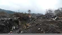
The former Village of San Miguel Los Lotes, buried by a pyroclastic flow from Volcán Fuego on June 3, 2018. It is now officially designated as a national cemetery by the Government of Guatemala.
References
- ↑ San Miguel Los Lotes, Escuintla. Guatemala. Open Street Map.
- ↑ "Guatemala volcano: Dozens die as Fuego volcano erupts". BBC News. 3 June 2018. Retrieved 3 June 2018.
- ↑ Death toll climbs to 109 in Guatemala volcano eruption. Reuters. Published by Yahoo! News. 7 June 2018.

This article is issued from
Wikipedia.
The text is licensed under Creative Commons - Attribution - Sharealike.
Additional terms may apply for the media files.