San Juan de Lurigancho
| San Juan de Lurigancho | ||
|---|---|---|
| District | ||
 | ||
| ||
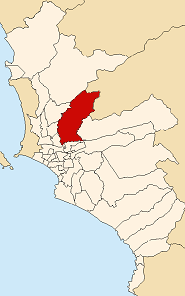 Location of San Juan de Lurigancho in Lima | ||
| Coordinates: 12°02′S 77°01′W / 12.033°S 77.017°WCoordinates: 12°02′S 77°01′W / 12.033°S 77.017°W | ||
| Country | Peru | |
| Region | Lima | |
| Province | Lima | |
| Founded | January 13, 1967 | |
| Capital | San Juan de Lurigancho | |
| Government | ||
| • Mayor | Carlos Burgos | |
| Area | ||
| • Total | 131.25 km2 (50.68 sq mi) | |
| Elevation | 220 m (720 ft) | |
| Population (2008 est.) | ||
| • Total | 1,106,453 | |
| • Density | 8,400/km2 (22,000/sq mi) | |
| Time zone | UTC-5 (PET) | |
| UBIGEO | 150132 | |
| Website | munisjl.gob.pe | |

San Juan de Lurigancho (SJL) is a district in Lima, Peru, located in the area known as Cono Este. It is Peru's most populous district, with a current population that may have exceeded one million.
On the north, it is bordered by the districts of Carabayllo and San Antonio, which is in the Huarochirí Province. San Juan de Lurigancho is bordered by Comas, Independencia and Rímac on the west; and Lurigancho on the east. The Rímac River marks the district's border with downtown Lima and El Agustino on the south.
The most important urban areas in the district are Mangomarca, Zárate, Las Flores de Lima, Canto Grande and Bayovar. One of the first urban areas in San Juan de Lurigancho is Caja de Agua, which is located at the entrance of the district. Caja de Agua is surrounded by San Cristobal (south side) and the Santa Rosa hills from south to west and by Gramal hill on the north side. The Próceres de la Independencia Avenue separates Caja de Agua from Zárate. Caja de Agua is the seat of the Police Station located in Avenida Lima. A large and convenient market is found in Avenida Lima; 'Mercado Modelo de Caja de Agua' which offers value for money products. Another market is 'El Bosque'. Also, Caja de Agua contains 3 local state schools which are in a very poor conditions, on the brink of being abandoned and closed due to the lack of students; these are 'Javier Heraud'; jirón Arequipa. 'Cesar Vallejo'; jirón Amazonas and 'Tomas Alva Edison'; which is located next to the market 'El Bosque'.
Climate
The summers tend to be rather dry. Summer is from October to April. May to September is a cold season. It seldom rains in this area, though the proximity to the coast brings cold humidity and fog in the winter.
Demographics
As of 2011, the district San Juan de Lurigancho has a population of approximately 1,004,300, the largest of Lima in terms of population.[1]
Transportation
San Juan de Lurigancho is serviced by many bus routes that connect it with almost all of the other districts in Lima.
The main route that connects San Juan de Lurigancho with the rest of the Lima and Callao Metropolitan Area is the Próceres de la Independencia Avenue. The Puente Nuevo, or New Bridge (actually a combination of two bridges with traffic going in opposite directions), inaugurated in 1993, provided a long-needed direct link to El Agustino and points south and east. Finally, the Lima Metro connects the district with the rest of Lima.
Another important transport link, a tunnel that will connect the districts of San Juan de Lurigancho with Rimac, has been halted. This tunnel is called Santa Rosa and San Martin, and was built up to 60% of its length but perforation of the tunnel was stopped due to some faults in the hill that was being excavated in March 2012. As of January 2014, construction has not resumed.
Other
Two of Peru's largest jails are located in San Juan de Lurigancho: Castro-Castro jail and San Juan de Lurigancho.
References
- ↑ "INEI, 2011". Retrieved 23 October 2012.
|first1=missing|last1=in Authors list (help)
External links
- Municipalidad de San Juan de Lurigancho - San Juan de Lurigancho district council official website. (in Spanish)
- 1.60 Gigapixel San Juan de Lurigancho
| Wikimedia Commons has media related to San Juan de Lurigancho District. |