San Cristovo de Cea
| San Cristovo de Cea | ||
|---|---|---|
| municipality | ||
| ||
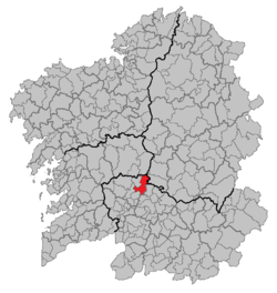 Location in Galicia | ||
 San Cristovo de Cea Location in Spain | ||
| Coordinates: 42°28′21″N 7°58′55″W / 42.47250°N 7.98194°WCoordinates: 42°28′21″N 7°58′55″W / 42.47250°N 7.98194°W | ||
| Country |
| |
| Autonomous community |
| |
| Province |
| |
| Comarca | O Carballiño | |
| Government | ||
| • Mayor | José Luis Valladares Fernández (People's Party of Galicia) | |
| Area[1] | ||
| • Total | 94.4 km2 (36.4 sq mi) | |
| Elevation | 526 m (1,726 ft) | |
| Population (2016)[2] | ||
| • Total | 2,303 | |
| • Density | 24/km2 (63/sq mi) | |
| Time zone | UTC+1 (CET) | |
| • Summer (DST) | UTC+2 (CEST) | |
| Website | www.concellodecea.com | |
San Cristovo de Cea is a municipality in Ourense (province) in the Galicia region of north-west Spain. It located towards in the north-west of the province.
References
- ↑ "IGE. Táboas". www.ige.eu (in Galician). Retrieved 2017-10-11.
- ↑ "IGE - Principais resultados". www.ige.eu (in Galician). Retrieved 2017-10-11.
This article is issued from
Wikipedia.
The text is licensed under Creative Commons - Attribution - Sharealike.
Additional terms may apply for the media files.