Samseong-dong
| Samseong-dong | |
|---|---|
| Korean transcription(s) | |
| • Hangul | 삼성동 |
| • Hanja | 三成洞 |
| • Revised Romanization | Samseong-dong |
| • McCune–Reischauer | Samsŏng-tong |
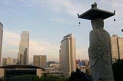 View of skyline from Bongeunsa | |
 | |
| Country | South Korea |
| Area | |
| • Total | 3.19 km2 (1.23 sq mi) |
| Population (2001)[1] | |
| • Total | 41,171 |
| • Density | 12,906/km2 (33,430/sq mi) |
Samseong-Dong is an affluent neighborhood or ward of Gangnam-gu in Seoul, South Korea.[1][2]
The area has a large concentration of upscale shopping malls, popular restaurants and world-renowned hotels such as the Ramada Seoul Hotel and the Hyatt Park Hotel. Samseong-dong is also home to some of Asia's best nightclubs that are frequently patronized by wealthy residents and celebrities. Apart from its nightlife accolades, the COEX mall, the world's largest underground shopping mall, is located in Samseong-dong.
History
- March 1, 1914 Gyeonggi-do District extension (Samseong-ri, Eonju-myeon, Gwangju-gun, Gyeonggi-do)
- January 1, 1963 Merged from Gyeonggi-do to Sudo-dong, Eonju Branch Office, Seoul
- May 18, 1970 Sudo-dong renamed as Cheongdam-dong
- September 1, 1977 Divided from Cheongdam-dong into Samseong-dong
- September 1, 1985 Samseong-dong dvided into Samseong-1-dong, Samseong-2-dong
Schools
Samseong-1-dong
- Seoul Bongeun Elementary School
- Bongeun Middle School
- Gyeonggi High School
Samsung-2-dong
- Seoul Samneung Elementary School
- Eonju Middle School
Attractions
Education
Schools located in Samseong-dong:
- Bongeun Elementary School
- Samreung Elementary School
- Bongeun Middle School
- Eonju Middle School
- Kyunggi High School
- Seoul Jungae School
Transport
- Seoul Subway Line 2
- Samseong Station
- Samsung Joongang Station
- Bongeunsa Station
- Seonjeongneung Station
- Bundang Line
- Seonjeongneung Station
- Yeongdong Highway
See also
References
- 1 2 "삼성동 (Samseong-Dong 三成洞)" (in Korean). Doosan encyclopedia. Retrieved 2008-04-14.
- ↑ "The origin of the names: Samseong-Dong" (in Korean). Gangnam-gu official site. Archived from the original on 2012-07-21. Retrieved 2008-04-14.
- ↑ Rachel Sang-hee Han; Frances Cha (17 December 2012). "13 things you've got to do in Seoul". CNN Travel. Retrieved 26 February 2013.
External links
- Samseong-dong official homepage (in Korean)
Coordinates: 37°30′50″N 127°03′23″E / 37.5140°N 127.0565°E
This article is issued from
Wikipedia.
The text is licensed under Creative Commons - Attribution - Sharealike.
Additional terms may apply for the media files.