Sambre
| Sambre | |
|---|---|
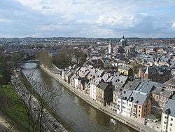 The Sambre in the centre of Namur | |
| Country | Belgium, France |
| Physical characteristics | |
| Main source |
Picardy 199 m (653 ft) |
| River mouth |
Meuse at Namur 50°27′43″N 4°52′15″E / 50.46194°N 4.87083°ECoordinates: 50°27′43″N 4°52′15″E / 50.46194°N 4.87083°E |
| Length | 193 km (120 mi) |
| Basin features | |
| Progression | Meuse→ North Sea |
| Basin size | 2,740 square kilometres (1,060 sq mi) |
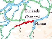
The Sambre [sɑ̃bʁ] is a river in northern France and in Wallonia, Belgium. It is a left-bank tributary of the Meuse, which it joins in the Wallonian capital Namur.
The source of the Sambre is near Le Nouvion-en-Thiérache, in the Aisne département. It passes through the Franco-Belgian coal basin, formerly an important industrial district. The navigable course begins in Landrecies at the junction with the Canal de la Sambre à l'Oise, which links with the central French waterway network (or did, until navigation was interrupted in 2006 following structural failures)[1]. It runs 54 km and 9 locks 38.50m long and 5.20m wide down to the Belgian border at Jeumont. From the border the river is canalised in two distinct section over a distance of 88 km with 17 locks. The Haute-Sambre is 39 km long and includes 10 locks of the same dimensions as in France, down to the industrial town of Charleroi. The rest of the Belgian Sambre was upgraded to European Class IV dimensions (1350-tonne barges) in the immediate post-World War II period. It lies at the western end of the sillon industriel, which is still Wallonia's industrial backbone, despite the cessation of all coal-mining and decline in the steel industry. The river flows into the Meuse at Namur, Belgium.
The navigable waterway is managed in France by Voies Navigables de France and in Belgium by the Service Public Wallon - Direction générale opérationnelle de la Mobilité et des Voies hydrauliques (Operational Directorate of Mobility and Inland Waterways)[2]
Course
The Sambre flows through the following départements of France, provinces of Belgium and towns:
- Aisne (F): Barzy-en-Thiérache
- Nord (F): Landrecies, Aulnoye-Aymeries, Hautmont, Maubeuge
- Hainaut (B): Thuin, Montigny-le-Tilleul, Charleroi
- Namur (B): Floreffe, Namur
 The Sambre at Aulne Abbey in Belgium
 The Sambre at Flawinne (Namur)
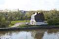 The Sambre at Ham-sur-Sambre
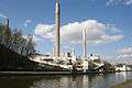 The Sambre at Moustier-sur-Sambre
Main tributaries
Events
- The mother of René Magritte, a famous surrealist painter, killed herself by drowning in this river.
Battles
The 19th-century theory that the Sambre was the location of Julius Caesar's battle against a Belgic confederation (57 BC), was discarded a long time ago,[5] but is still repeated.
Heavy fighting occurred along the river during World War I, especially at the siege of Namur in 1914 (Battle of Charleroi) and in the last month of the war Battle of the Sambre (1918).
References
- ↑ Edwards-May, David (2010). Inland Waterways of France. St Ives, Cambs., UK: Imray. pp. 246–249. ISBN 978-1-846230-14-1.
- ↑ Edwards-May, David (2014). European Waterways Map and Concise Directory. Lambersart, France: Transmanche. pp. 11–12, 17-20 and fold-out map. ISBN 979-10-94429-00-6.
- 1 2 3 4 5 6 7 8 9 10 11 12 13 "Contrats de rivière en Wallonie - Sambre". Environnement.wallonie.be. Retrieved 25 March 2018.
- ↑ "Le Ruisseau "le Piéton" - Piéton, Village du Hainaut". Pieton.eu. Retrieved 25 March 2018.
- ↑ Pierre Turquin ("La Bataille de la Selle (du Sabis) en l' An 57 avant J.-C." in Les Études Classiques 23/2 (1955), 113-156) has proved beyond reasonable doubt that the battle was fought at the River Selle, west of modern Saulzoir.
External links
| Wikimedia Commons has media related to Sambre. |
- The Sambre in the Sandre database (in French) for basic catchment area data.
- River Sambre and Canal de la Sambre à l'Oise with maps and details of places, moorings and facilities for boats, by the author of Inland Waterways of France, Imray
- Navigation details for 80 French rivers and canals (French waterways website section)