Samacasa
| Samacasa | |
|---|---|
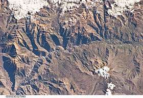 The Colca River and Samacasa northwest of it (upper left) as seen from the ISS | |
| Highest point | |
| Elevation | 5,200 m (17,100 ft) [1] |
| Coordinates | 15°25′09″S 72°06′22″W / 15.41917°S 72.10611°WCoordinates: 15°25′09″S 72°06′22″W / 15.41917°S 72.10611°W |
| Geography | |
 Samacasa Peru | |
| Location | Peru, Arequipa Region |
| Parent range | Andes, Chila |
Samacasa (possibly from Aymara sama color, Quechua sama rest, break, q'asa mountain pass)[2][3] is a mountain in the Chila mountain range in the Andes of Peru, about 5,200 m (17,100 ft) high. It is located in the Arequipa Region, Castilla Province, Chachas District. Samacasa lies north of Airicoto.[1]
References
- 1 2 escale.minedu.gob.pe - UGEL map of the Caylloma Province (1) (Arequipa Region)
- ↑ Radio San Gabriel, "Instituto Radiofonico de Promoción Aymara" (IRPA) 1993, Republicado por Instituto de las Lenguas y Literaturas Andinas-Amazónicas (ILLLA-A) 2011, Transcripción del Vocabulario de la Lengua Aymara, P. Ludovico Bertonio 1612 (Spanish-Aymara-Aymara-Spanish dictionary)
- ↑ Teofilo Laime Ajacopa, Diccionario Bilingüe Iskay simipi yuyayk'ancha, La Paz, 2007 (Quechua-Spanish dictionary)
This article is issued from
Wikipedia.
The text is licensed under Creative Commons - Attribution - Sharealike.
Additional terms may apply for the media files.