Airicoto
| Airicoto | |
|---|---|
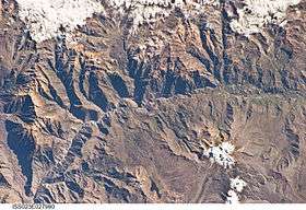 The Colca River and Airicoto north of it (upper left) as seen from the ISS | |
| Highest point | |
| Elevation | 5,400 m (17,700 ft) [1] |
| Coordinates | 15°26′56″S 72°06′11″W / 15.44889°S 72.10306°WCoordinates: 15°26′56″S 72°06′11″W / 15.44889°S 72.10306°W |
| Geography | |
 Airicoto Peru | |
| Location | Peru, Arequipa Region, Castilla Province |
| Parent range | Andes, Chila |
Airicoto (possibly from Quechua ayri axe, qutu heap,[2] "axe heap") is a mountain in the Chila mountain in the Andes of Peru, about 5,400 m (17,700 ft) high. It is located in the Arequipa Region, Castilla Province, Choco District. It lies northeast of Quiscapampa and east of Yuraccacsa.[1]
Airicoto is also the name of the valley west of the mountain. Its waters flow to Colca River in the south.[1]
References
This article is issued from
Wikipedia.
The text is licensed under Creative Commons - Attribution - Sharealike.
Additional terms may apply for the media files.