Salem, Wellington County
| Salem | |
|---|---|
| Compact Rural Community | |
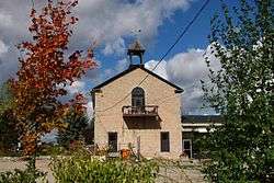 Original school house in Salem. | |
 Salem Location in southern Ontario | |
| Coordinates: 43°41′36″N 80°26′49″W / 43.69333°N 80.44694°WCoordinates: 43°41′36″N 80°26′49″W / 43.69333°N 80.44694°W[1] | |
| Country | Canada |
| Province | Ontario |
| County | Wellington County |
| Township | Centre Wellington |
| Elevation[2] | 400 m (1,300 ft) |
| Time zone | UTC-5 (EST) |
| • Summer (DST) | UTC-4 (EDT) |
| Forward sortation area | N0G 1S0 |
| Area code(s) | 519, 226, 548 |
| NTS Map | 040P09 |
| GNBC Code | FDTDG |
Salem is a compact rural community and unincorporated place in the incorporated township of Centre Wellington, Wellington County, in southwestern Ontario, Canada.[1][3][4]
Salem is the site of a gas station, local convenience store, two bridges over Irvine Creek, a school, and a subdivision. It also has one traffic light, but has more gravel roads than paved ones. The community is known for its many historic stone houses.
In recent years, Salem's size has grown due to an urban development on William Street, between Water Street and Victoria Street.
References
- 1 2 "Salem". Geographical Names Data Base. Natural Resources Canada. Retrieved 2017-03-10.
- ↑ Elevation taken at geographic coordinates from Google Maps. Accessed 2017-03-10.
- ↑ Map 2 (PDF) (Map). 1 : 700,000. Official road map of Ontario. Ministry of Transportation of Ontario. 2015-01-01. Retrieved 2017-03-10.
- ↑ Restructured municipalities - Ontario map #6 (Map). Restructuring Maps of Ontario. Ontario Ministry of Municipal Affairs and Housing. 2006. Retrieved 2017-03-10.
This article is issued from
Wikipedia.
The text is licensed under Creative Commons - Attribution - Sharealike.
Additional terms may apply for the media files.