Salay, Misamis Oriental
| Salay | |
|---|---|
| Municipality | |
| Municipality of Salay | |
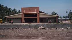 New Municipal Public Market | |
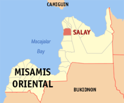 Map of Misamis Oriental with Salay highlighted | |
.svg.png) Salay Location within the Philippines | |
| Coordinates: 8°52′N 124°48′E / 8.87°N 124.8°ECoordinates: 8°52′N 124°48′E / 8.87°N 124.8°E | |
| Country |
|
| Region | Northern Mindanao (Region X) |
| Province | Misamis Oriental |
| District | 1st District |
| Founded | January 1, 1920 (Executive Order No. 94, s. 1919) |
| Barangays | 18 (see Barangays) |
| Government [1] | |
| • Type | Sangguniang Bayan |
| • Mayor | Angelo G. Capistrano Jr. |
| • Electorate | 19,211 voters (2016) |
| Area [2] | |
| • Total | 92.79 km2 (35.83 sq mi) |
| Population (2015 census)[3] | |
| • Total | 28,705 |
| • Density | 310/km2 (800/sq mi) |
| Time zone | UTC+8 (PST) |
| ZIP code | 9007 |
| PSGC | 104322000 |
| IDD : area code | +63 (0)88 |
| Climate type | Tropical climate |
| Income class | 4th municipal income class |
| Revenue (₱) | 84,057,174.85 (2016) |
| Native languages |
Cebuano Binukid Subanon language Tagalog |
| Website |
www |
Salay, officially the Municipality of Salay, is a 4th class municipality in the province of Misamis Oriental, Philippines. According to the 2015 census, it has a population of 28,705 people.[3] The town is known for its handmade paper and papercrafts, similar to washi, but made with indigenous fibers.[4]
Poblacion is the center of Salay and had been governed by the Capistrano politicians until the 2007 elections. Lanzones is one of the major source of income among Salayanos aside from commerce at Poblacion and fishing to other people. May 1 is the official feast day of Salay although March feast is also celebrated and is the original.
Salay Central School provides primary education to the graders in this town while the nearby Salay National High School provides the secondary education, the latter has been nationally recognized for quality education among public schools.
Barangays
Salay is politically subdivided into 18 barangays.
- Alipuaton
- Ampenican
- Bunal
- Casulog
- Dinagsaan
- Guinalaban
- Ili-ilihon
- Inobulan
- Looc
- Matampa
- Membuli
- Poblacion
- Salagsag
- Salay River I
- Salay River II
- Saray
- Tinagaan
- Yungod
Demographics
| Population census of Salay | ||||||||||||||||||||||||||||||||||||||||||||||
|---|---|---|---|---|---|---|---|---|---|---|---|---|---|---|---|---|---|---|---|---|---|---|---|---|---|---|---|---|---|---|---|---|---|---|---|---|---|---|---|---|---|---|---|---|---|---|
|
| |||||||||||||||||||||||||||||||||||||||||||||
| Source: Philippine Statistics Authority[3][5][6][7] | ||||||||||||||||||||||||||||||||||||||||||||||
In the 2015 census, the population of Salay, Misamis Oriental, was 28,705 people,[3] with a density of 310 inhabitants per square kilometre or 800 inhabitants per square mile.
References
- ↑ "Municipality". Quezon City, Philippines: Department of the Interior and Local Government. Retrieved 31 May 2013.
- ↑ "Province: Misamis Oriental". PSGC Interactive. Quezon City, Philippines: Philippine Statistics Authority. Retrieved 12 November 2016.
- 1 2 3 4 Census of Population (2015). "Region X (Northern Mindanao)". Total Population by Province, City, Municipality and Barangay. PSA. Retrieved 20 June 2016.
- ↑ https://www.tenthousandvillages.com/salay
- ↑ Census of Population and Housing (2010). "Region X (Northern Mindanao)". Total Population by Province, City, Municipality and Barangay. NSO. Retrieved 29 June 2016.
- ↑ Censuses of Population (1903–2007). "Region X (Northern Mindanao)". Table 1. Population Enumerated in Various Censuses by Province/Highly Urbanized City: 1903 to 2007. NSO.
- ↑ "Province of Misamis Oriental". Municipality Population Data. Local Water Utilities Administration Research Division. Retrieved 17 December 2016.
External links
- Philippine Standard Geographic Code
- Philippine Census Information
- Local Governance Performance Management System
Places adjacent to Salay, Misamis Oriental | |
|---|---|
Cagayan de Oro (capital) | |
| Municipalities | |
| Component cities | |
| Highly urbanized city |
|