Sainte-Ursule, Quebec
| Sainte-Ursule | |
|---|---|
| Parish municipality | |
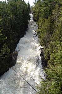 Sainte-Ursule Falls | |
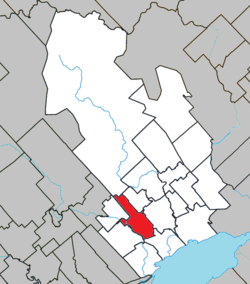 Location within Maskinongé RCM. | |
 Sainte-Ursule Location in central Quebec. | |
| Coordinates: 46°17′N 73°02′W / 46.283°N 73.033°WCoordinates: 46°17′N 73°02′W / 46.283°N 73.033°W[1] | |
| Country |
|
| Province |
|
| Region | Mauricie |
| RCM | Maskinongé |
| Constituted | July 1, 1855 |
| Government[2] | |
| • Mayor | Réjean Carle |
| • Federal riding | Berthier—Maskinongé |
| • Prov. riding | Maskinongé |
| Area[2][3] | |
| • Total | 68.20 km2 (26.33 sq mi) |
| • Land | 67.91 km2 (26.22 sq mi) |
| Population (2011)[3] | |
| • Total | 1,375 |
| • Density | 20.2/km2 (52/sq mi) |
| • Pop 2006-2011 |
|
| • Dwellings | 682 |
| Time zone | UTC−5 (EST) |
| • Summer (DST) | UTC−4 (EDT) |
| Postal code(s) | J0K 3M0 |
| Area code(s) | 819 |
| Highways |
|
| Website |
www |
Sainte-Ursule is a parish municipality in the Mauricie region of the province of Quebec in Canada.
References
Places adjacent to Sainte-Ursule, Quebec | |
|---|---|
| Cities & towns | |
|---|---|
| Municipalities | |
| Parishes | |
This article is issued from
Wikipedia.
The text is licensed under Creative Commons - Attribution - Sharealike.
Additional terms may apply for the media files.