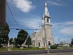
Saint-Léon-le-Grand, Mauricie, Quebec
| Saint-Léon-le-Grand | |
|---|---|
| Parish municipality | |
 | |
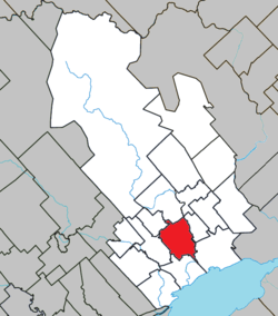 Location within Maskinongé RCM. | |
 Saint-Léon-le-Grand Location in central Quebec. | |
| Coordinates: 46°19′N 72°56′W / 46.317°N 72.933°WCoordinates: 46°19′N 72°56′W / 46.317°N 72.933°W[1] | |
| Country |
|
| Province |
|
| Region | Mauricie |
| RCM | Maskinongé |
| Constituted | July 1, 1855 |
| Named for | Pope Leo I[1] |
| Government[2] | |
| • Mayor | Robert Lalonde |
| • Federal riding | Berthier—Maskinongé |
| • Prov. riding | Maskinongé |
| Area[2][3] | |
| • Total | 75.90 km2 (29.31 sq mi) |
| • Land | 76.64 km2 (29.59 sq mi) |
|
There is an apparent contradiction between two authoritative sources | |
| Population (2011)[3] | |
| • Total | 992 |
| • Density | 12.9/km2 (33/sq mi) |
| • Pop 2006-2011 |
|
| • Dwellings | 401 |
| Time zone | UTC−5 (EST) |
| • Summer (DST) | UTC−4 (EDT) |
| Postal code(s) | J0K 2W0 |
| Area code(s) | 819 |
| Highways |
|
Saint-Léon-le-Grand is a parish municipality in the Maskinongé Regional County Municipality in the Mauricie region of the province of Quebec, Canada.
Demographics
Population trend:[4]
- Population in 2011: 992 (2006 to 2011 population change: 2.8%)
- Population in 2006: 965
- Population in 2001: 966
- Population in 1996: 955
- Population in 1991: 925
Private dwellings occupied by usual residents: 388 (total dwellings: 401)
Mother tongue:
- English as first language: 0%
- French as first language: 100%
- English and French as first language: 0%
- Other as first language: 0%
References
- 1 2 Reference number 57072 of the Commission de toponymie du Québec (in French)
- 1 2 Geographic code 51035 in the official Répertoire des municipalités (in French)
- 1 2 "(Code 2451035) Census Profile". 2011 census. Statistics Canada. 2012.
- ↑ Statistics Canada: 1996, 2001, 2006, 2011 census
| Wikimedia Commons has media related to Saint-Léon-le-Grand (Maskinongé). |
Places adjacent to Saint-Léon-le-Grand, Mauricie, Quebec | ||||||||||
|---|---|---|---|---|---|---|---|---|---|---|
| ||||||||||
| Cities & towns | |
|---|---|
| Municipalities | |
| Parishes | |
This article is issued from
Wikipedia.
The text is licensed under Creative Commons - Attribution - Sharealike.
Additional terms may apply for the media files.