Saint-Paul, Réunion
| Saint-Paul | ||
|---|---|---|
| Subprefecture and commune | ||
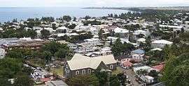 A view over the town centre and the gulf of Saint-Paul | ||
| ||
 | ||
| Coordinates: 21°00′35″S 55°16′11″E / 21.0097°S 55.2697°ECoordinates: 21°00′35″S 55°16′11″E / 21.0097°S 55.2697°E | ||
| Country | France | |
| Overseas region and department | Réunion | |
| Arrondissement | Saint-Paul | |
| Canton | 3 cantons | |
| Intercommunality | Territoire de la Côte Ouest | |
| Government | ||
| • Mayor (2014-2020) | Joseph Sinimalé (UMP) | |
| Area1 | 241.28 km2 (93.16 sq mi) | |
| Population (2012)2 | 104,646 | |
| • Density | 430/km2 (1,100/sq mi) | |
| INSEE/Postal code | 97415 /97460 | |
| Elevation |
0–2,955 m (0–9,695 ft) (avg. 4 m or 13 ft) | |
|
1 French Land Register data, which excludes lakes, ponds, glaciers > 1 km2 (0.386 sq mi or 247 acres) and river estuaries. 2 Population without double counting: residents of multiple communes (e.g., students and military personnel) only counted once. | ||
.svg.png)
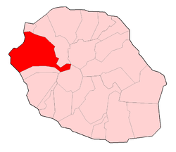
Saint-Paul (French pronunciation: [sɛ̃.pɔl]) is the second-largest commune in the French overseas department of Réunion. It is located on the extreme west side of the island of Réunion.
Until 1999, near Saint Paul there was the 428 metres tall mast OMEGA Chabrier transmitter.
Transport
Saint-Paul will be the western terminus of the proposed Réunion Tram Train (abandoned project).

Saint-Gilles
See also
References
External links
- Official website (in French)
- Video du Marché
| Wikimedia Commons has media related to Saint-Paul, Réunion. |
This article is issued from
Wikipedia.
The text is licensed under Creative Commons - Attribution - Sharealike.
Additional terms may apply for the media files.