Saint-Benoît, Réunion
| Saint-Benoît | |
|---|---|
| Subprefecture and commune | |
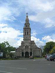 The church of Sainte-Anne in the commune of Saint-Benoît | |
 | |
| Coordinates: 21°02′02″S 55°42′46″E / 21.0339°S 55.7128°ECoordinates: 21°02′02″S 55°42′46″E / 21.0339°S 55.7128°E | |
| Country | France |
| Overseas region and department | Réunion |
| Arrondissement | Saint-Benoît |
| Canton | Saint-Benoît-1 and 2 |
| Intercommunality | Réunion Est |
| Government | |
| • Mayor (2014-2020) | Jean-Claude Fruteau (PS) |
| Area1 | 229.61 km2 (88.65 sq mi) |
| Population (2011)2 | 35,733 |
| • Density | 160/km2 (400/sq mi) |
| INSEE/Postal code | 97410 /97470 |
| Elevation |
0–2,520 m (0–8,268 ft) (avg. 7 m or 23 ft) |
|
1 French Land Register data, which excludes lakes, ponds, glaciers > 1 km2 (0.386 sq mi or 247 acres) and river estuaries. 2 Population without double counting: residents of multiple communes (e.g., students and military personnel) only counted once. | |
Saint-Benoît (French pronunciation: [sɛ̃.bə.nwa]) is a commune in the French overseas department of Réunion. It is located on the eastern part of the island of Réunion, about 40 kilometres southeast of Saint-Denis, the capital.
Geography
In the west of the commune lies Grand Étang, the largest lake of La Réunion. Close to the lake flows the Bras d'Annette waterfall.
See also
References
| Wikimedia Commons has media related to Saint-Benoît, Réunion. |
This article is issued from
Wikipedia.
The text is licensed under Creative Commons - Attribution - Sharealike.
Additional terms may apply for the media files.