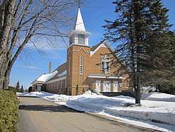
Saint-Mathieu-du-Parc, Quebec
| Saint-Mathieu-du-Parc | |
|---|---|
| Municipality | |
 | |
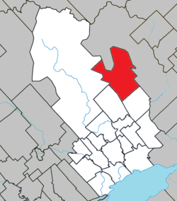 Location within Maskinongé RCM. | |
 Saint-Mathieu-du-Parc Location in central Quebec. | |
| Coordinates: 46°34′N 72°55′W / 46.567°N 72.917°WCoordinates: 46°34′N 72°55′W / 46.567°N 72.917°W[1] | |
| Country |
|
| Province |
|
| Region | Mauricie |
| RCM | Maskinongé |
| Constituted | June 30, 1886 |
| Government[2] | |
| • Mayor | Claude Mayrand |
| • Federal riding | Berthier—Maskinongé |
| • Prov. riding | Saint-Maurice |
| Area[2][3] | |
| • Total | 228.10 km2 (88.07 sq mi) |
| • Land | 221.95 km2 (85.70 sq mi) |
| Population (2011)[3] | |
| • Total | 1,407 |
| • Density | 6.3/km2 (16/sq mi) |
| • Pop 2006-2011 |
|
| • Dwellings | 1,242 |
| Time zone | UTC−5 (EST) |
| • Summer (DST) | UTC−4 (EDT) |
| Postal code(s) | G0X 1N0 |
| Area code(s) | 819 |
| Highways |
|
| Website |
www |
Saint-Mathieu-du-Parc is a municipality in the Mauricie region of the province of Quebec in Canada. Prior to March 28, 1998, it was known simply as Saint-Mathieu.
It is home to the Mokotakan Museum, showcasing the First Nations of Quebec.
References
External links

Places adjacent to Saint-Mathieu-du-Parc, Quebec | ||||||||||
|---|---|---|---|---|---|---|---|---|---|---|
| ||||||||||
| Cities & towns | |
|---|---|
| Municipalities | |
| Parishes | |
This article is issued from
Wikipedia.
The text is licensed under Creative Commons - Attribution - Sharealike.
Additional terms may apply for the media files.