Saint-Laurent-Lolmie
| Saint-Laurent-Lolmie | |
|---|---|
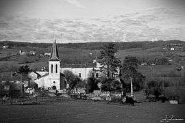 The church, cemetery and castle of Lolmie | |
 Saint-Laurent-Lolmie Location within Occitanie region  Saint-Laurent-Lolmie | |
| Coordinates: 44°17′35″N 1°13′45″E / 44.2931°N 1.2292°ECoordinates: 44°17′35″N 1°13′45″E / 44.2931°N 1.2292°E | |
| Country | France |
| Region | Occitanie |
| Department | Lot |
| Arrondissement | Cahors |
| Canton | Luzech |
| Area1 | 10.81 km2 (4.17 sq mi) |
| Population (1999)2 | 202 |
| • Density | 19/km2 (48/sq mi) |
| Time zone | UTC+1 (CET) |
| • Summer (DST) | UTC+2 (CEST) |
| INSEE/Postal code | 46274 /46800 |
| Elevation |
127–270 m (417–886 ft) (avg. 214 m or 702 ft) |
|
1 French Land Register data, which excludes lakes, ponds, glaciers > 1 km2 (0.386 sq mi or 247 acres) and river estuaries. 2 Population without double counting: residents of multiple communes (e.g., students and military personnel) only counted once. | |
Saint-Laurent-Lolmie is a former commune in the Lot department in south-western France. On 1 January 2018, it was merged into the new commune of Lendou-en-Quercy. [1]
Originally known simply as Saint-Laurent, the commune was renamed Saint-Laurent-Lolmie by a decree dated December 25, 1918. [2]
Geography
Saint-Laurent and Lolmie are two different places a mile apart, and linked by the Lendou valley.
See also
References
- ↑ "Arrêté du 6 décembre 2017 portant création de la commune nouvelle de Lendou-en-Quercy". Légifrance. December 27, 2017. Retrieved January 20, 2018.
- ↑ "Journal officiel de la République française" (in French). January 22, 1919. Retrieved January 20, 2018.
External Links
| Wikimedia Commons has media related to Saint-Laurent-Lolmie. |
This article is issued from
Wikipedia.
The text is licensed under Creative Commons - Attribution - Sharealike.
Additional terms may apply for the media files.