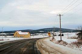
Saint-Herménégilde, Quebec
| Saint-Herménégilde | |
|---|---|
| Municipality | |
 | |
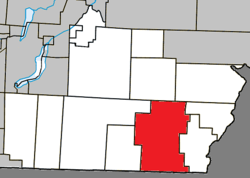 Location within Coaticook RCM. | |
 St-Herménégilde Location in southern Quebec. | |
| Coordinates: 45°06′N 71°40′W / 45.100°N 71.667°WCoordinates: 45°06′N 71°40′W / 45.100°N 71.667°W[1] | |
| Country |
|
| Province |
|
| Region | Estrie |
| RCM | Coaticook |
| Constituted | October 12, 1985 |
| Government[2] | |
| • Mayor | Lucie Tremblay |
| • Federal riding | Compton—Stanstead |
| • Prov. riding | Saint-François |
| Area[2][3] | |
| • Total | 168.80 km2 (65.17 sq mi) |
| • Land | 166.72 km2 (64.37 sq mi) |
| Population (2011)[3] | |
| • Total | 702 |
| • Density | 4.2/km2 (11/sq mi) |
| • Pop 2006-2011 |
|
| • Dwellings | 510 |
| Time zone | UTC−5 (EST) |
| • Summer (DST) | UTC−4 (EDT) |
| Postal code(s) | J0B 2W0 |
| Area code(s) | 819 |
| Highways |
|
| Website |
www |
Saint-Herménégilde is a municipality in Quebec.
Demographics
Population
Population trend:[4]
| Census | Population | Change (%) |
|---|---|---|
| 2011 | 702 | |
| 2006 | 718 | |
| 2001 | 595 | |
| 1996 | 616 | |
| 1991 | 575 | N/A |
References
- ↑ Reference number 56712 of the Commission de toponymie du Québec (in French)
- 1 2 Geographic code 44015 in the official Répertoire des municipalités (in French)
- 1 2 "(Code 2444015) Census Profile". 2011 census. Statistics Canada. 2012.
- ↑ Statistics Canada: 1996, 2001, 2006, 2011 census
Places adjacent to Saint-Herménégilde, Quebec | |
|---|---|
| Cities | |
|---|---|
| Municipalities | |
| Townships | |
| Communities | |
| |
This article is issued from
Wikipedia.
The text is licensed under Creative Commons - Attribution - Sharealike.
Additional terms may apply for the media files.