Coaticook
| Coaticook | |
|---|---|
| City | |
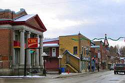 Main Street | |
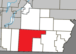 Location within Coaticook RCM. | |
 Coaticook Location in southern Quebec. | |
| Coordinates: 45°08′N 71°48′W / 45.133°N 71.800°WCoordinates: 45°08′N 71°48′W / 45.133°N 71.800°W[1] | |
| Country |
|
| Province |
|
| Region | Estrie |
| RCM | Coaticook |
| Settled | 1820s |
| Constituted | December 30, 1998 |
| Government[2] | |
| • Mayor | Simon Madore |
| • Federal riding | Compton—Stanstead |
| • Prov. riding | Saint-François |
| Area[2][3] | |
| • Total | 223.60 km2 (86.33 sq mi) |
| • Land | 218.57 km2 (84.39 sq mi) |
| Population (2011)[3] | |
| • Total | 9,255 |
| • Density | 42.3/km2 (110/sq mi) |
| • Pop 2006-2011 |
|
| • Dwellings | 4,208 |
| Time zone | UTC−5 (EST) |
| • Summer (DST) | UTC−4 (EDT) |
| Postal code(s) | J1A |
| Area code(s) | 819 |
| Highways |
|
| Website |
www |
Coaticook is a town in southeastern Quebec, Canada on the Coaticook River; it is the seat of the Coaticook Regional County Municipality. Its southern border is also the Canada–United States border.
Communities
In addition to the primary community of Coaticook, smaller communities now within the municipal boundaries include Baldwin's Mills, Barnston, Ladd's Mills and Stanhope. Stanhope was a separate community in the 1890s and has a small private airport, the Stanhope Airport.
Demographics
Population
| Canada census – Coaticook community profile | |||
|---|---|---|---|
| 2011 | 2006 | ||
| Population: | 9,255 (+0.6% from 2006) | 9,204 (+2.4% from 2001) | |
| Land area: | 218.57 km2 (84.39 sq mi) | 218.55 km2 (84.38 sq mi) | |
| Population density: | 42.3/km2 (110/sq mi) | 42.1/km2 (109/sq mi) | |
| Median age: | 44.1 (M: 42.9, F: 45.4) | 41.0 (M: 40.1, F: 41.9) | |
| Total private dwellings: | 4,208 | 3978 | |
| Median household income: | $43,230 | $42,647 | |
| Notes: Counts have been adjusted to reflect 2001 Census boundaries. Population in 1996: 6,653[4] (+0.2% from 1991) - Population in 1991: 6,637[4] – References: 2011[3] 2006[5] earlier[6] | |||
Mother tongue:[7]
- English as first language: 5.5%
- French as first language: 92.3%
- English and French as first language: 0.6%
- Other as first language: 1.6%
Cemeteries
Cemeteries in or near Coaticook include Mount Forest Cemetery,[8] Saint Edmond Cemetery,[9][10] St-Luc and St-Wilfrid-de-Barnston.
Climate
| Climate data for Coaticook, Quebec | |||||||||||||
|---|---|---|---|---|---|---|---|---|---|---|---|---|---|
| Month | Jan | Feb | Mar | Apr | May | Jun | Jul | Aug | Sep | Oct | Nov | Dec | Year |
| Record high °C (°F) | 17.8 (64) |
17.0 (62.6) |
24.5 (76.1) |
29.5 (85.1) |
31.7 (89.1) |
33.3 (91.9) |
35.0 (95) |
34.4 (93.9) |
32.2 (90) |
28.9 (84) |
25.0 (77) |
17.8 (64) |
35.0 (95) |
| Average high °C (°F) | −5.1 (22.8) |
−2.8 (27) |
2.4 (36.3) |
10.4 (50.7) |
17.6 (63.7) |
22.4 (72.3) |
24.6 (76.3) |
23.6 (74.5) |
19.1 (66.4) |
11.8 (53.2) |
5.0 (41) |
−1.9 (28.6) |
10.6 (51.1) |
| Daily mean °C (°F) | −9.8 (14.4) |
−7.9 (17.8) |
−2.5 (27.5) |
5.3 (41.5) |
12.0 (53.6) |
17.0 (62.6) |
19.4 (66.9) |
18.4 (65.1) |
14.1 (57.4) |
7.4 (45.3) |
1.3 (34.3) |
−6.0 (21.2) |
5.7 (42.3) |
| Average low °C (°F) | −14.5 (5.9) |
−12.9 (8.8) |
−7.3 (18.9) |
0.2 (32.4) |
6.3 (43.3) |
11.6 (52.9) |
14.1 (57.4) |
13.2 (55.8) |
9.0 (48.2) |
2.9 (37.2) |
−2.5 (27.5) |
−10 (14) |
0.8 (33.4) |
| Record low °C (°F) | −41.7 (−43.1) |
−36.1 (−33) |
−29.4 (−20.9) |
−20.0 (−4) |
−7.8 (18) |
−2.2 (28) |
−1.1 (30) |
−1.1 (30) |
−5.6 (21.9) |
−10.6 (12.9) |
−25.0 (−13) |
−36.1 (−33) |
−41.7 (−43.1) |
| Average precipitation mm (inches) | 80.9 (3.185) |
69.8 (2.748) |
76.3 (3.004) |
81.2 (3.197) |
101.1 (3.98) |
124.7 (4.909) |
116.1 (4.571) |
128.9 (5.075) |
96.5 (3.799) |
104.8 (4.126) |
96.9 (3.815) |
98.8 (3.89) |
1,176 (46.299) |
| Average rainfall mm (inches) | 22.2 (0.874) |
18.0 (0.709) |
29.6 (1.165) |
67.9 (2.673) |
100.1 (3.941) |
124.7 (4.909) |
116.1 (4.571) |
128.9 (5.075) |
96.5 (3.799) |
100.2 (3.945) |
70.7 (2.783) |
33.6 (1.323) |
908.6 (35.772) |
| Average snowfall cm (inches) | 58.7 (23.11) |
51.9 (20.43) |
46.7 (18.39) |
14.1 (5.55) |
1.0 (0.39) |
0.0 (0) |
0.0 (0) |
0.0 (0) |
0.0 (0) |
4.6 (1.81) |
26.2 (10.31) |
65.2 (25.67) |
268.3 (105.63) |
| Source: Environment Canada[11] | |||||||||||||
Sports
Coaticook is home to the Coaticook Big Bill of the Ligue de Baseball Senior Élite du Québec, which play their home games in Julien Morin Stadium.
Pictures of Coaticook
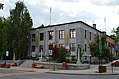 Coaticook city hall.
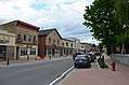 Child street in 2014.
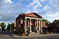 Eastern Townships Bank, Main street.
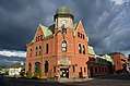 Coaticook post office.
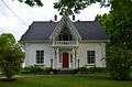 Gérin House, built in 1851.
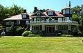 Beaulne House in Coaticook.
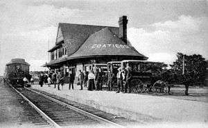 Railroad station in Coaticook.
See also
References
- ↑ Reference number 351657 of the Commission de toponymie du Québec (in French)
- 1 2 "Coaticook". Répertoire des municipalités (in French). Ministère des Affaires municipales, des Régions et de l'Occupation du territoire. Retrieved 2012-01-16.
- 1 2 3 "2011 Community Profiles". Canada 2011 Census. Statistics Canada. July 5, 2013. Retrieved 2014-01-28.
- 1 2 "Electronic Area Profiles". Canada 1996 Census. Statistics Canada. Retrieved 2014-01-28.
- ↑ "2006 Community Profiles". Canada 2006 Census. Statistics Canada. March 30, 2011. Retrieved 2012-01-16.
- ↑ "2001 Community Profiles". Canada 2001 Census. Statistics Canada. February 17, 2012.
- ↑ "Coaticook community profile". 2006 Census data. Statistics Canada. Retrieved 2012-01-16.
- ↑ "Mount Forest Cemetery, Coaticook, Stanstead County, Quebec". interment.net. Retrieved 2009-11-08.
- ↑ "Liste des cimetières du diocèse". Cimetière Saint-Michel-de-Sherbrooke (in French). Retrieved 2009-11-08.
- ↑ "Saint Edmond Cemetery, Coaticook, Stanstead County, Quebec". interment.net. Retrieved 2009-11-08.
- ↑ "Coaticook, Quebec Climate". Canadian Climate Normals 1981–2010 (in English and French). Environment Canada. Retrieved July 16, 2015.
External links
| Wikimedia Commons has media related to Coaticook. |
- (in French) Ville de Coaticook
Adjacent Municipal Subdivisions | |
|---|---|
| Cities | |
|---|---|
| Municipalities | |
| Townships | |
| Communities | |
| |