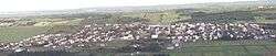
Saint-Fabien, Quebec
| Saint-Fabien | |
|---|---|
| Parish municipality | |
 | |
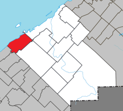 Location within Rimouski-Neigette RCM | |
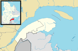 Saint-Fabien Location in eastern Quebec | |
| Coordinates: 48°18′N 68°52′W / 48.3°N 68.87°WCoordinates: 48°18′N 68°52′W / 48.3°N 68.87°W[1] | |
| Country |
|
| Province |
|
| Region | Bas-Saint-Laurent |
| RCM | Rimouski-Neigette |
| Constituted | July 1, 1855 |
| Government[2] | |
| • Mayor | Marnie Perreault |
| • Federal riding | Rimouski-Neigette—Témiscouata—Les Basques |
| • Prov. riding | Rimouski |
| Area[2][3] | |
| • Total | 124.10 km2 (47.92 sq mi) |
| • Land | 120.24 km2 (46.42 sq mi) |
| Population (2011)[3] | |
| • Total | 1,906 |
| • Density | 15.9/km2 (41/sq mi) |
| • Pop 2006-2011 |
|
| • Dwellings | 1,199 |
| Time zone | UTC−5 (EST) |
| • Summer (DST) | UTC−4 (EDT) |
| Postal code(s) | G0L 2Z0 |
| Area code(s) | 418 and 581 |
| Highways |
|
| Website |
www |
Saint-Fabien is a parish municipality in the Canadian province of Quebec, located in the Rimouski-Neigette Regional County Municipality.
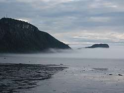
Baie du Ha! Ha! in Bic National Park
See also
References
External links

Adjacent Municipal Subdivisions | |
|---|---|
| Cities & Towns | |
|---|---|
| Municipalities | |
| Parishes | |
| Unorganized territories | |
| |
This article is issued from
Wikipedia.
The text is licensed under Creative Commons - Attribution - Sharealike.
Additional terms may apply for the media files.