Sagae, Yamagata
| Sagae 寒河江市 | |||
|---|---|---|---|
| City | |||
 Sagae City Hall | |||
| |||
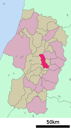 Location of Sagae in Yamagata Prefecture | |||
 Sagae | |||
| Coordinates: 38°22′51.3″N 140°16′33.7″E / 38.380917°N 140.276028°ECoordinates: 38°22′51.3″N 140°16′33.7″E / 38.380917°N 140.276028°E | |||
| Country | Japan | ||
| Region | Tōhoku | ||
| Prefecture | Yamagata | ||
| Area | |||
| • Total | 139.03 km2 (53.68 sq mi) | ||
| Population (October 2015) | |||
| • Total | 41,174 | ||
| • Density | 296/km2 (770/sq mi) | ||
| Time zone | UTC+9 (Japan Standard Time) | ||
| - Tree | Cherry | ||
| - Flower | Azalea | ||
| - Plant | Sagae Gibōshi (Hosta ‘Sagae’) | ||
| -Fish | Ayu | ||
| Phone number | 0237-86-2111 | ||
| Address | 1-9-45 Chūō, Sagae-shi, Yamagata-ken 991-8601 | ||
| Website | http://www.city.sagae.yamagata.jp/ | ||


Sagae (寒河江市 Sagae-shi) is a city located in Yamagata Prefecture, Japan. As of October 2015, the city had an estimated population of 41,174, and a population density of 296 persons per km². The total area is 139.03 square kilometres (54 sq mi).
Geography
Sagae is located in the Yamagata Basin in the geographic center of Yamagata Prefecture. The Asahi Mountains and Dewa Mountains form its western border, and the Mogami River forms the eastern border of the city.
Neighboring municipalities
Climate
Sagae has a Humid continental climate (Köppen climate classification Dfa) with large seasonal temperature differences, with warm to hot (and often humid) summers and cold (sometimes severely cold) winters. Precipitation is significant throughout the year, but is heaviest from August to October.
History
The area of present-day Sagae was part of ancient Dewa Province, and has been settled since prehistoric times, with numerous archaeological findings from the Japanese Paleolithic through the Kofun periods. In the late Heian through Kamakura periods, it was a shōen under the control of the Ōe clan. The Ōe were destroyed by the Mogami clan in the Sengoku period, who were in turn destroyed by the Tokugawa shogunate in the early Edo period. The territory was administered as tenryō under direct control of the shogunate until the Meiji Restoration, and was briefly a battleground in the Boshin War. After the start of the Meiji period, the area became part of Nishimurayama District, Yamagata Prefecture. The modern village of Sagae was established on April 1, 1889, and was raised to town status on January 7, 1893. It became a city on August 1, 1954.
Economy
The economy of Sagae is primarily based on agriculture.
Transportation
Railway
Highway
- Yamagata Expressway: Sagae interchange; Sagae parking area (ETC exit gate)
- National Route 112
- National Route 287
- National Route 347
- National Route 458
Local attractions
- Sagae is famous for its Cherryland tourist attraction. Yamagata Prefecture is the largest producer of cherries in Japan.
- Jion-in temple,a national historic monument
Sister cities
Noted people from Sagae
- Hiroh Kikai - photographer
References
- 1 2 "International Exchange". List of Affiliation Partners within Prefectures. Council of Local Authorities for International Relations (CLAIR). Retrieved 21 November 2015.
External links
![]()
- Official Website (in Japanese)
| Special city | ||
|---|---|---|
| Cities | ||
| Districts | ||
| Authority control |
|---|