Sachse, Texas
| Sachse, Texas | |
|---|---|
| City | |
 Sachse City Hall | |
 Location in Dallas County and the state of Texas | |
| Coordinates: 32°58′35″N 96°35′10″W / 32.97639°N 96.58611°WCoordinates: 32°58′35″N 96°35′10″W / 32.97639°N 96.58611°W | |
| Country |
|
| State |
|
| Counties | Dallas |
| Government | |
| • Type | Council-Manager |
| • City Council |
Mayor Mike Felix Mayor Pro-Tem Cullen King Jeff Bickerstaff Bill Adams Michelle Howarth Brett Franks Paul Watkins |
| • City Manager | Gina Nash |
| Area | |
| • Total | 9.9 sq mi (25.6 km2) |
| • Land | 9.7 sq mi (25.2 km2) |
| • Water | 0.2 sq mi (0.4 km2) 1.62% |
| Elevation | 548 ft (167 m) |
| Population (2010) | |
| • Total | 20,329 |
| • Density | 2,100/sq mi (790/km2) |
| Time zone | UTC-6 (Central) |
| • Summer (DST) | UTC-5 (Central) |
| ZIP code | 75048 |
| Area code(s) | 972, 214, 469 |
| FIPS code | 48-64064[1] |
| GNIS feature ID | 1345812[2] |
| Website | http://www.cityofsachse.com |
Sachse (/ˈsæksi/ SAK-see) is a city in Collin and Dallas counties in the U.S. state of Texas and is part of the DFW Metroplex. A northeastern suburb of Dallas, the city population was 20,329, as of the 2010 census with an estimated population of around 25,000 people today.[3] Sachse is located off Texas State Highway 78 and is approximately 1 mile (1.6 km) north of the President George Bush Turnpike (Texas State Highway 190) and Firewheel Town Center.
History
Sachse was founded by William Sachse, a European immigrant from Herford, Prussia (included modern-day Germany, and parts of Poland and Eastern Europe), in 1845. Purchasing 640 acres (2.6 km2) from Collin County, Sachse erected the first cotton mills and gins in the county. After Sachse gave 100 feet of frontage through all of his holdings to the railroad in 1886, the railroad built a depot on the frontage and named the town Sachse. Since the depot was labeled 'Saxie', many old legal documents referred to the city as 'Saxie'. The flaw was later corrected. The word Sachse comes from the German word for Saxon.[4]
Geography
Sachse is located at 32°58′35″N 96°35′10″W / 32.976433°N 96.586138°W (32.976433, -96.586138).[5]
According to the United States Census Bureau, the city has a total area of 25.6 square kilometers (9.9 sq mi). 25.2 km2 (9.7 sq mi) of it is land and 0.4 km2 (0.2 sq mi) of it (1.62%) is water.
Education
Sachse residents living in Dallas County attend schools in Garland Independent School District. Sachse residents living in Collin County attend schools in Wylie Independent School District.
Armstrong Elementary School, Sewell Elementary, Hudson Middle School, and Sachse High School serve Garland ISD within Sachse city limits. Garland ISD has a "choice-of-school" system that allows any student in the district to attend any school.
Cox Elementary School and Whitt Elementary School serve Wylie ISD within Sachse city limits. Wylie ISD has feeder school system in which each school feeds into the next school. Cox Elementary feeds into Harrison Intermediate School, Burnett Junior High School, and Wylie East High School and Whitt Elementary School feeds into Draper Intermediate School, Cooper Junior High School, and Wylie High School. All the secondary schools are located within the city of Wylie.[6]
Local government
Incorporated in 1956, the City of Sachse adopted its Home Rule Charter in 1986 and is served by the North Central Texas Council of Governments. The city council is composed of a mayor and six (6) council members. Each is elected at-large, serving 3-year staggered terms with no term limits. Operating under a Council-Manager form of government, Sachse is a full-service city.
Demographics
| Historical population | |||
|---|---|---|---|
| Census | Pop. | %± | |
| 1960 | 359 | — | |
| 1970 | 777 | 116.4% | |
| 1980 | 1,640 | 111.1% | |
| 1990 | 5,346 | 226.0% | |
| 2000 | 9,751 | 82.4% | |
| 2010 | 20,329 | 108.5% | |
| Est. 2016 | 25,039 | [7] | 23.2% |
| U.S. Decennial Census[8] | |||
As of the census[1] of 2000, there were 9,751 people, 3,224 households, and 2,746 families residing in the city. The population density was 1,001.8 people per square mile (386.9/km2). There were 3,350 housing units at an average density of 344.2 per square mile (132.9/km2). The racial makeup of the city was 87.34% White, 4.63% African American, 0.65% Native American, 2.15% Asian, 0.01% Pacific Islander, 3.37% from other races, and 1.85% from two or more races. Hispanic or Latino of any race were 8.21% of the population.
There were 3,224 households out of which 51.5% had children under the age of 18 living with them, 75.3% were married couples living together, 7.1% had a female householder with no husband present, and 14.8% were non-families. 11.2% of all households were made up of individuals and 2.2% had someone living alone who was 65 years of age or older. The average household size was 3.02 and the average family size was 3.28.
In the city, the population was spread out with 32.7% under the age of 18, 6.1% from 18 to 24, 39.3% from 25 to 44, 17.9% from 45 to 64, and 4.0% who were 65 years of age or older. The median age was 32 years. For every 100 females, there were 99.2 males. For every 100 females age 18 and over, there were 97.5 males.
The median income for a household in the city was $70,333, and the median income for a family was $71,918. Males had a median income of $50,582 versus $35,174 for females. The per capita income for the city was $25,530. About 3.4% of families and 4.6% of the population were below the poverty line, including 4.5% of those under age 18 and 11.1% of those age 65 or over.
References
- 1 2 "American FactFinder". United States Census Bureau. Archived from the original on 2013-09-11. Retrieved 2008-01-31.
- ↑ "US Board on Geographic Names". United States Geological Survey. 2007-10-25. Archived from the original on 2012-02-26. Retrieved 2008-01-31.
- ↑ "Profile of General Population and Housing Characteristics: 2010 Demographic Profile Data (DP-1): Sachse city, Texas". U.S. Census Bureau, American Factfinder. Archived from the original on September 11, 2013. Retrieved January 19, 2012.
- ↑ "History of Sachse". cityofsachse.com. Archived from the original on 9 December 2010. Retrieved 27 April 2018.
- ↑ "US Gazetteer files: 2010, 2000, and 1990". United States Census Bureau. 2011-02-12. Archived from the original on 2012-03-12. Retrieved 2011-04-23.
- ↑ "Archived copy" (PDF). Archived (PDF) from the original on 2017-12-04. Retrieved 2017-12-03.
- ↑ "Population and Housing Unit Estimates". Archived from the original on May 29, 2017. Retrieved June 9, 2017.
- ↑ "Census of Population and Housing". Census.gov. Archived from the original on May 12, 2015. Retrieved June 4, 2015.
External links
- City of Sachse official website
- Sachse Chamber of Commerce
- Sachse Economic Development Corporation
- Friends of Sachse Parks and Recreation
- Sachse Historical Society
- Sachse Community Emergency Response Team
Municipalities and communities of Collin County, Texas, United States | ||
|---|---|---|
| Cities | 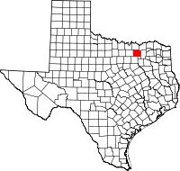 | |
| Towns | ||
| CDP | ||
| Other unincorporated communities |
| |
| Historical communities | ||
| Ghost towns | ||
| Footnotes | ‡This populated place also has portions in an adjacent county or counties | |
Municipalities and communities of Dallas County, Texas, United States | ||
|---|---|---|
| Cities | 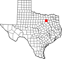 | |
| Towns | ||
| Unincorporated communities | ||
| Historical communities | ||
| Footnotes | ‡This populated place also has portions in an adjacent county or counties | |