Sabang, Indonesia
| Sabang | ||
|---|---|---|
| City | ||
| Other transcription(s) | ||
| • Jawoë | سابڠ | |
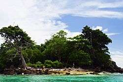 Rubiah Island, Sabang | ||
| ||
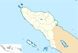 Location within Aceh | ||
| Coordinates: 5°53′39″N 95°19′9″E / 5.89417°N 95.31917°ECoordinates: 5°53′39″N 95°19′9″E / 5.89417°N 95.31917°E | ||
| Country |
| |
| Province |
| |
| Government | ||
| • Mayor | Nazaruddin | |
| • Vice Mayor | Suradji | |
| Area | ||
| • Total | 153.00 km2 (59.07 sq mi) | |
| Population (2014 Estimate) | ||
| • Total | 32,271[1] | |
| Time zone | UTC+7 (Indonesia Western Time) | |
| Area code | (+62) 652 | |
| Website | sabangkota.go.id | |


Sabang is a city consisting of a main island (Weh Island) and several smaller islands off the northern tip of Sumatra. The islands form a city within Aceh Special Region, Indonesia. The administrative centre is located on Weh Island, 17 km north of Banda Aceh. The city covers an area of 153.0 square kilometres and according to the 2010 census had a population of 30,653 people;[2] the latest estimate (for January 2014) is 32,271.[1] Sabang is also known as the northernmost and westernmost city of Indonesia.
The Japanese occupied the island and installed numerous bunkers, fortifications and gun emplacements. Their remnants can still be seen, though most have been re-purposed or removed. On 6 May 1943, the Imperial Japanese Navy's submarine, the I-29, tasked with a Yanagi mission, landed the Indian leader and freedom fighter, Netaji Subhash Chandra Bose and his lieutenant, Abid Hasan at Sabang on Weh Island, instead of the Penang, to avoid detection by British spies.
Islands
- Klah Island (0.186 km²)
- Rondo Island (0.650 km²)
- Rubiah Island (0.357 km²)
- Seulako Island (0.055 km²)
- Weh Island (121 km²)
Administrative districts
The city is divided into two districts (kecamatan), listed below with their populations at the 2010 Census:
| Kecamatan | Population at 2010 Census[3] |
No. of Villages |
|---|---|---|
| Sukajaya | 15,542 | 10 |
| Sukakarya | 15,111 | 8 |
Villages
Sabang has 18 villages in two districts (Sukajaya and Sukakarya). With the details, Sukajaya has 10 villages and Sukakarya has 8 villages. Listed below with the name of all villages in Sabang with 2016 data:
| Villages | Kecamatan |
|---|---|
| Paya | Sukajaya |
| Keunekai | Sukajaya |
| Beurawan | Sukajaya |
| Jaboi | Sukajaya |
| Balohan | Sukajaya |
| Cot Abeuk | Sukajaya |
| Cot Ba'u | Sukajaya |
| Anoi Itam | Sukajaya |
| Ujong Kareung | Sukajaya |
| Ie Meule | Sukajaya |
| Iboih | Sukakarya |
| Batee Shok | Sukakarya |
| Paya Seunara | Sukakarya |
| Krueng Raya | Sukakarya |
| Aneuk Laot | Sukakarya |
| Kota Bawah Timur | Sukakarya |
| Kota Bawah Barat | Sukakarya |
| Kota Atas | Sukakarya |

Airport
Sabang is served by the Maimun Saleh Airport. The airport is located southeast of the central city on Weh Island.
International sail tourism event
The City hosted an international sail tourism event in September 2011. The sail race was participated in by around 50 ships with 15 crew members each. Besides sailing they visited interesting places packed in a 'tsunami' tourism, visit Gapang Beach and Iboih Beach with enchanting underwater scenery.[4]
Sail Sabang 2017 will held from Nov. 28 until Dec. 5 in Sabang. The event is the ninth installment of Sail Indonesia, an annual yacht rally that was first launched in 2009 on Bunaken Island, North Sulawesi.[5]
See also
References
- 1 2 http://www.depkes.go.id/downloads/Penduduk%20Kab%20Kota%20Umur%20Tunggal%202014.pdf Estimasi Penduduk Menurut Umur Tunggal Dan Jenis Kelamin 2014 Kementerian Kesehatan
- ↑ Seta,William J. Atlas Lengkap Indonesia dan Dunia (untuk SD, SMP, SMU, dan Umum). Pustaka Widyatama. p. 7. ISBN 979-610-232-3.
- ↑ Biro Pusat Statistik, Jakarta, 2011.
- ↑ RH, Priyambodo (28 May 2011). "Sabang to host sail tourism event in September". antaranews.com. Retrieved 13 December 2013.
- ↑ "Sail Sabang 2017 aims to put Aceh on global tourism map". The Jakarta Post. Retrieved 22 November 2017.
External links
| Wikivoyage has a travel guide for Sabang (Indonesia). |
- (in Indonesian) Official Sabang City
Regencies and cities of Aceh | ||
|---|---|---|
Capital: Banda Aceh | ||
| Regencies |  | |
| Cities | ||
| Authority control |
|---|