Sa Pobla
| Sa Pobla | ||
|---|---|---|
| Municipality | ||
| ||
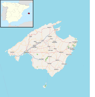 Sa Pobla Location in Majorca  Sa Pobla Sa Pobla (Balearic Islands)  Sa Pobla Sa Pobla (Spain) | ||
| Coordinates: 39°46′9″N 3°1′21″E / 39.76917°N 3.02250°E | ||
| Country | Spain | |
| Autonomous community | Balearic Islands | |
| Province | Balearic Islands | |
| Comarca | Raiguer | |
| Judicial district | Inca | |
| Government | ||
| • Mayor | Joan Comas Reus | |
| Area | ||
| • Total | 48.59 km2 (18.76 sq mi) | |
| Elevation | 28 m (92 ft) | |
| Population (2009) | ||
| • Total | 12,766 | |
| • Density | 260/km2 (680/sq mi) | |
| Demonym(s) | Poblers | |
| Time zone | UTC+1 (CET) | |
| • Summer (DST) | UTC+2 (CEST) | |
| Postal code | 07420 | |

Sa Pobla (Catalan pronunciation: [sə ˈpɔbːlə]) is a small municipality in the district of Raiguer on Majorca, one of the Spanish Balearic Islands. It is a terminus on the Majorca rail network.
The town is in the north of the island. With an area of 48.53 square kilometres (18.74 sq mi), stretching from the Serra de Tramuntana, the Plan and the Bay of Alcúdia. It comprises three very different areas: the Marjal, fertile plains in large part devoted to irrigated agriculture; l 'lagoon, a large area of scenic and ecological value where the streams and San Miguel de Muro (of Almadrà).
External links
This article is issued from
Wikipedia.
The text is licensed under Creative Commons - Attribution - Sharealike.
Additional terms may apply for the media files.