Oklahoma State Highway 72
| ||||
|---|---|---|---|---|
 | ||||
| Route information | ||||
| Maintained by ODOT | ||||
| Length | 32.9 mi (52.9 km) | |||
| Major junctions | ||||
| South end |
| |||
| North end |
| |||
| Highway system | ||||
|
Oklahoma State Highway System
| ||||

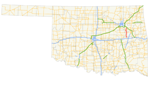
State Highway 72 (abbreviated SH-72 or OK-72) is a state highway in the U.S. state of Oklahoma. It runs from north to south through the east-central part of the state, with a length of almost 33 miles[1] (53 km). It does not have any lettered spur routes.
Route description
SH-72 begins at U.S. Highway 266 west of Checotah and heads north, passing through Council Hill after 4 miles (6.4 km). Two miles south of Boynton, it meets US-62, which it starts a duplex with. Past Boynton, it has a junction with US-64 and SH-16; US-62 splits off of SH-72 and US-64 joins it.
Near Haskell, US-64 splits off SH-72, headed towards Tulsa. SH-72 continues northward to cross the Arkansas River, to Coweta.
Junction list
| County | Location | mi[1] | km | Destinations | Notes |
|---|---|---|---|---|---|
| McIntosh | | 0.0 | 0.0 | Southern terminus | |
| Muskogee | | 7.7 | 12.4 | ||
| Jamesville | 16.8 | 27.0 | |||
| 16.8 | 27.0 | ||||
| 16.8 | 27.0 | ||||
| Haskell | 22.7 | 36.5 | |||
| 23.1 | 37.2 | ||||
| Wagoner | Coweta | 32.1 | 51.7 | ||
| 32.9 | 52.9 | Northern terminus | |||
1.000 mi = 1.609 km; 1.000 km = 0.621 mi
| |||||
References
External links
This article is issued from
Wikipedia.
The text is licensed under Creative Commons - Attribution - Sharealike.
Additional terms may apply for the media files.