Söse
| Söse | |
|---|---|
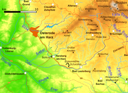 The southwestern Harz with the River Söse | |
| State | Lower Saxony, Germany |
| Reference no. | DE: 48828 |
| Physical characteristics | |
| Main source |
Auf dem Acker in the Harz ca. 800 m above sea level (NN) |
| River mouth |
Into the Rhume near Katlenburg-Lindau 130 m above sea level (NN) 51°41′58″N 10°06′24″E / 51.6995°N 10.106556°E |
| Length | 37.8 km (23.5 mi) [1] |
| Discharge |
|
| Basin features | |
| Progression | Rhume→ Leine→ Aller→ Weser→ North Sea |
| Basin size | 213 km2 (82 sq mi) [1] |
| Landmarks | Large towns: Osterode |
| Tributaries |
|
| Waterbodies | Reservoirs: Söse Reservoir |

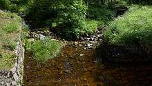
The Söse is a right tributary of the river Rhume, 38 kilometres long, in Lower Saxony, Germany.
Geography
The river rises on the plateau of Auf dem Acker in the district of Göttingen in the southwestern part of the Harz Mountains in Germany. From there it flows initially westwards; and is then impounded at a pre-dam and then by the Söse Dam between the Osterode village of Riefensbeek and the town of Osterode am Harz itself. In Osterode the river bends northwest, only to swing westwards near Badenhausen and then southwards near Eisdorf just a few kilometres west of the Harz. It flows in that direction through Osterode-Dorste before entering the westward-flowing Rhume between the villages of Berka and Elvershausen, both part of the borough of Katlenburg-Lindau in the district of Northeim.
Tributaries
- Große Söse ("Great Söse", left headstream)
- Kleine Söse ("Little Söse", right headstream)
- Große Limpig (right)
- Eipenke (left)
- Ospenke (left)
- Lerbach (right)
- Apenke (left)
- Große Bremke (right)
- Wellbeek (right)
- Uferbach (right)
- Sulpebach (right)
- Markau (right)
- Bierbach (right)
- Dornkesbach (right)
- Goldbach (right)
- Salza (left)
- Dorster Mühlenbach (left)
Walking
At the confluence of the Great Söse and the Great Morgenbrod is the Morgenbrodt Hut (ca. 600 bis 605 m above NN[3]; 146 – Morgenbrodt Hut 51°45′45″N 10°26′45″E / 51.76260°N 10.44573°E). This spot is no. 148[4] in the system of checkpoints in the Harzer Wandernadel hiking network. The Morgenbrodt Hut was demolished in 2013 by the National Park Authority as it was falling down and it is not intended to be replaced.[5]
References
- 1 2 Environmental map service of Lower Saxony (Umweltkartendienst des Niedersächsischen Ministeriums für Umwelt, Energie und Klimaschutz)
- ↑ "Deutsches Gewässerkundliches Jahrbuch Weser-Ems 2008" (PDF) (in German). Niedersächsischer Landesbetrieb für Wasserwirtschaft, Küsten- und Naturschutz. 2012. Retrieved 2012-10-07.
- ↑ Map services of the Federal Agency for Nature Conservation
- ↑ Harzer Wandernadel: Stempelstelle 146 – Morgenbrodtshütte Archived 2016-03-05 at the Wayback Machine. at harzer-wandernadel.de
- ↑ Pressemitteilung des Nationalpark Harz