Sânzieni
| Sânzieni Kézdiszentlélek | ||
|---|---|---|
| Commune | ||
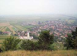 The village from the peak Perkő | ||
| ||
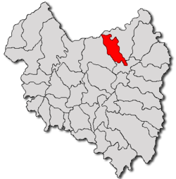 Location of Sânzieni | ||
| Coordinates: 46°03′0″N 26°08′0″E / 46.05000°N 26.13333°ECoordinates: 46°03′0″N 26°08′0″E / 46.05000°N 26.13333°E | ||
| Country |
| |
| County | Covasna County | |
| Status | Commune | |
| Government | ||
| • Mayor | István László (Independent) | |
| Population (2011) | ||
| • Total | 4,563 | |
| Time zone | UTC+2 (EET) | |
| • Summer (DST) | UTC+3 (EEST) | |

Sânzieni (Hungarian: Kézdiszentlélek, Hungarian pronunciation: [ˈkeːzdisɛntleːlɛk]) is a commune in Covasna County, Transylvania, Romania composed of four villages:
- Cașinu Mic / Kiskászon
- Petriceni / Kézdikővár
- Sânzieni / Kézdiszentlélek
- Valea Seacă / Kézdiszárazpatak
History
Sânzieni formed part of the Székely Land region of the historical Transylvania province. Until 1918, the village belonged to the Háromszék County of the Kingdom of Hungary. After the Treaty of Trianon of 1920, it became part of Romania.
Demographics
The commune has an absolute Székely Hungarian majority. According to the 2011 census, it has a population of 4,563, of which 99.17% or 4,525 are Hungarian.
International relations
Twin towns – Sister cities
Sânzieni is twinned with:

Historical Map - Josephinische Landaufnahme 1769-1773
References
- ↑ "Újbuda története" [Újbuda - New in History, Twin Towns]. Rafia.hu (in Hungarian). Archived from the original on 2013-05-21. Retrieved 2013-08-11.
This article is issued from
Wikipedia.
The text is licensed under Creative Commons - Attribution - Sharealike.
Additional terms may apply for the media files.