Dimminsdale
| Site of Special Scientific Interest | |
 | |
| Area of Search |
Derbyshire Leicestershire |
|---|---|
| Grid reference | SK 377 218 [1] |
| Interest |
Biological Geological |
| Area | 37.0 hectares[1] |
| Notification | 1986[1] |
| Location map | Magic Map |
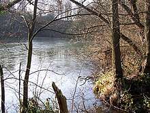
Dimminsdale is a 37 hectare geological biological and Site of Special Scientific Interest partly in Derbyshire and partly in Leicestershire. It is located east of Calke in Derbyshire.[1][2] It is a Geological Conservation Review site,[3] and a area of 23.5 hectares is owned by Severn Trent Water and managed by the Leicestershire and Rutland Wildlife Trust.[4]
Dimminsdale has semi-natural woodland and one of the largest areas of unimproved acidic grassland in the county. Earl Ferrers' lead mine, which is located on the site, has a unique and complex mixture of minerals such as galena and zinc blende; their genesis is little understood and they provide great potential for research.[5]
There is public access to footpaths on the nature reserve part of the site.
References
- 1 2 3 4 "Designated Sites View: Dimminsdale". Sites of Special Scientific Interest. Natural England. Retrieved 11 November 2017.
- ↑ "Map of Dimminsdale". Sites of Special Scientific Interest. Natural England. Retrieved 11 November 2017.
- ↑ "Earl Ferrers` Lead Mine (Mineralogy of Peak District, Leicestershire, Cheshire & Shropshire)". Geological Conservation Review. Joint Nature Conservation Committee. Retrieved 11 November 2017.
- ↑ "Dimminsdale". Leicestershire and Rutland Wildlife Trust. Retrieved 11 November 2017.
- ↑ "Dimminsdale citation" (PDF). Sites of Special Scientific Interest. Natural England. Retrieved 11 November 2017.
| Wikimedia Commons has media related to Dimminsdale. |