Rurrenabaque
| Rurrenabaque | |
|---|---|
| Town and municipality | |
 | |
 Rurrenabaque Location of Rurrenabaque town in Bolivia | |
| Coordinates: 14°26′32″S 67°31′42″W / 14.44222°S 67.52833°W | |
| Country |
|
| Department |
|
| Province | José Ballivián Province |
| Population (2012) | |
| • Total | 19,195 |
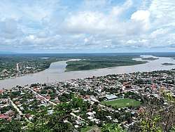
Rurrenabaque is a small town in the North of Bolivia on the Beni River. It is the capital of Rurrenabaque Municipality. In recent years it has become popular with international tourism as it is an easy gateway for visits to Madidi National Park (within the Bolivian rainforest), as well as the surrounding pampas. Locals commonly refer to the town by its shortened nickname, "Rurre."
Rurrenabaque is located in José Ballivián Province in Beni Department, Bolivia. Rurrenabaque Municipality, the fourth (municipal section) of José Ballivián Province, had 19,195 inhabitants, of which 13,446 lived in urban Rurrenabaque itself in 2012.[1]
Transportation
Rurrenabaque is reached by bus, 410 km (250 mi) from La Paz (18 hours), by hired taxi (12 hours) or by airplane (45 minutes-1 hour). Three airlines have flights to Rurrenabaque: Amaszonas, Aerocon and TAM - Transporte Aéreo Militar.
The buses from La Paz pass through Coroico, 70 km (43 mi) from La Paz. A new road on this route opened at the end of 2006, decreasing most motorized traffic on the older, more dangerous 'Death Road,' now highly popular for mountain bike tours. The 'Death Road' is also called the Yungas Road.
Rurrenabaque Airport was paved in 2010. Low clouds over nearby mountains can hinder planes' visibility and can prevent planes from landing.
A nearby airport can also be used, Reyes Airport, which is 32 kilometres (20 mi) and about one hour by bus. There are no mountains near Reyes, and the airport often has better weather and fewer low clouds. Reyes is the capital of José Ballivián Province in the Beni Department.
Rurrenabaque lies on the east bank of the Beni River. It is expected that a bridge will be built over the river to connect with the town San Buenaventura on the west bank. The planned bridge is a part of a regional road project, promoted as a way to improve the economic relationship between the two towns, which has been described as stunted because of limited and expensive transport by boat. An argument in favor of the proposed bridge is that the shallows and strong currents at the San Buenaventura section limit the types of boats and motors capable of crossing the stretch of river, representing an investment beyond the means of most individual Bolivian families; a bridge would allow San Buenaventura to enjoy the same accessibility as that enjoyed between Rurrenabaque and the neighboring town of Reyes. As of 2017, the bridge had not yet been built. A possible reason for the delay is that the local population resists the planned scheme for road and bridge placement. Researchers cite economic and social harm for the area because of environmental damage from the road project and the planned location of the bridge, which would reduce the town's appeal as a destination/gateway for eco-tourists.[2]
Tourism
From Rurrenabaque popular tours go to the jungle/rainforest ("selva" in Spanish) and to the pampas. The jungle/rainforest is south and west of Rurrenabaque (including a part of the Madidi National Park), and the tours leave by boat and foot. There are many tour agencies in the town offering similar tours.
Rurrenabaque is a starting point for ecotourism, and some eco-lodges are found in the area. The following is a list of the community based Eco-Lodges-: Mashaquipe; San Louis Grande (Mosetén); Berraco del Madidi (Quechua-Tacanas); San Miguel del Bala (Tacanas); Chalalán (Quechua-Tacanas); Mapajo (Tsiman-Mosetén)
Events, festivities: The 2nd of February: Fiesta de Rurre - Anniversary of Rurrenabaque - The day of La Virgen de Candelaria.
External links
| Wikivoyage has a travel guide for Rurrenabaque. |
References
Coordinates: 14°26′32″S 67°31′42″W / 14.44222°S 67.52833°W
Capital: La Santísima Trinidad | ||
| Provinces | 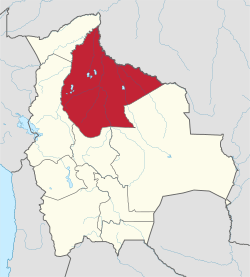 | |
| Municipalities and seats |
| |