Ruff's Mill and Concord Covered Bridge
|
Ruff's Mill and Concord Covered Bridge | |
 | |
 | |
| Location | 10 Concord Rd., SW, Smyrna, Georgia |
|---|---|
| Coordinates | 33°50′56″N 84°33′30″W / 33.84889°N 84.55833°WCoordinates: 33°50′56″N 84°33′30″W / 33.84889°N 84.55833°W |
| Area | 3.5 acres (1.4 ha) |
| Built | c.1864 |
| Architectural style | Plantation Plain |
| NRHP reference # | 80001001[1] |
| Added to NRHP | November 24, 1980 |
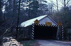
Ruff's Mill and Concord Covered Bridge, in Smyrna, Georgia, was listed on the National Register of Historic Places in 1980.[1]
The site includes a gristmill building, the miller's house, and a covered bridge.[2]
References
- 1 2 National Park Service (2013-11-02). "National Register Information System". National Register of Historic Places. National Park Service.
- ↑ Kenneth H. Thomas, Jr.; Richard Cloues (August 1980). "National Register of Historic Places Inventory/Nomination: Ruff's Mill and Concord Covered Bridge". National Park Service. Retrieved September 12, 2018. With accompanying eight photos from 1980
| Topics | |
|---|---|
| Lists by states |
|
| Lists by insular areas | |
| Lists by associated states | |
| Other areas | |
| |
This article is issued from
Wikipedia.
The text is licensed under Creative Commons - Attribution - Sharealike.
Additional terms may apply for the media files.