Rucheng County
| Rucheng County 汝城县 | |
|---|---|
| County | |
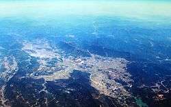 Rucheng County from above | |
 Rucheng Location in Hunan | |
| Coordinates: 25°33′07″N 113°41′02″E / 25.552°N 113.684°ECoordinates: 25°33′07″N 113°41′02″E / 25.552°N 113.684°E[1] | |
| Country | People's Republic of China |
| Province | Hunan |
| Prefecture-level city | Chenzhou |
| Time zone | UTC+8 (China Standard) |
| Postal code | 4241XX |
Rucheng County (simplified Chinese: 汝城县; traditional Chinese: 汝城縣; pinyin: Rǔchéng Xiàn) is a county in Hunan Province, China, it is under the administration of Chenzhou prefecture-level City.
Located on the southeastern corner of the province, the county is bordered to the northwest by Yizhang County, to the north by Zixing City, to the northeast by Guidong County, to the east by Chongyi County, to the southeast by Renhua County, to the southwest by Lechang City. Rucheng County covers 2,400.71 km2 (926.92 sq mi), as of 2015, It had a registered population of 407,200 and a resident population of 344,400.[2] The county has 9 towns and 5 townships under its jurisdiction, the county seat is Luyang Town (卢阳镇).[3]
Rucheng County is also the home of the Yao people, Yao ethnic minority accounts for 15.27% of the population; Another local minority is She people, it accounts for 0.24% of the population in the county.[4]
Climate
| Climate data for Rucheng (1981−2010) | |||||||||||||
|---|---|---|---|---|---|---|---|---|---|---|---|---|---|
| Month | Jan | Feb | Mar | Apr | May | Jun | Jul | Aug | Sep | Oct | Nov | Dec | Year |
| Record high °C (°F) | 22.7 (72.9) |
26.8 (80.2) |
29.2 (84.6) |
31.0 (87.8) |
32.8 (91) |
33.8 (92.8) |
36.7 (98.1) |
37.3 (99.1) |
34.7 (94.5) |
33.4 (92.1) |
29.5 (85.1) |
24.2 (75.6) |
37.3 (99.1) |
| Average high °C (°F) | 11.3 (52.3) |
12.8 (55) |
15.9 (60.6) |
21.4 (70.5) |
25.3 (77.5) |
27.9 (82.2) |
30.2 (86.4) |
30.2 (86.4) |
27.6 (81.7) |
24.0 (75.2) |
19.0 (66.2) |
14.3 (57.7) |
21.7 (71) |
| Daily mean °C (°F) | 6.5 (43.7) |
8.5 (47.3) |
11.9 (53.4) |
17.3 (63.1) |
21.2 (70.2) |
23.9 (75) |
25.6 (78.1) |
25.1 (77.2) |
22.5 (72.5) |
18.3 (64.9) |
13.1 (55.6) |
8.1 (46.6) |
16.8 (62.3) |
| Average low °C (°F) | 3.2 (37.8) |
5.5 (41.9) |
8.9 (48) |
14.3 (57.7) |
18.0 (64.4) |
21.1 (70) |
22.2 (72) |
21.7 (71.1) |
19.0 (66.2) |
14.3 (57.7) |
8.8 (47.8) |
3.8 (38.8) |
13.4 (56.1) |
| Record low °C (°F) | −5.5 (22.1) |
−4.5 (23.9) |
−3.4 (25.9) |
2.2 (36) |
7.1 (44.8) |
11.8 (53.2) |
17.7 (63.9) |
16.5 (61.7) |
10.7 (51.3) |
1.9 (35.4) |
−2.1 (28.2) |
−7.8 (18) |
−7.8 (18) |
| Average precipitation mm (inches) | 69.4 (2.732) |
102.6 (4.039) |
151.0 (5.945) |
183.9 (7.24) |
194.7 (7.665) |
219.5 (8.642) |
171.0 (6.732) |
174.6 (6.874) |
106.3 (4.185) |
64.5 (2.539) |
51.6 (2.031) |
38.5 (1.516) |
1,527.6 (60.14) |
| Average relative humidity (%) | 82 | 84 | 86 | 85 | 84 | 85 | 81 | 83 | 82 | 79 | 78 | 77 | 82 |
| Source: China Meteorological Data Service Center | |||||||||||||
References
- ↑ Google (2014-07-02). "Rucheng" (Map). Google Maps. Google. Retrieved 2014-07-02.
- ↑ about the population of Rucheng County in 2015, according to the Statistical Communiqué of Rucheng County on the 2015 National Economic and Social Development - (2015年汝城县国民经济和社会发展统计公报): czs.gov.cn or hsj.czs.gov
- ↑ the divisions of Rucheng County in 2015, according to the result on adjustment of township-level administrative divisions of Rucheng County on November 27, 2015 - 《湖南省民政厅关于同意汝城县乡镇区划调整方案的批复》(湘民行发〔2015〕100号): rednet.cn, also see 《湖南省乡镇区划调整改革109个县市区批复方案》: people.com or xinhuanet.com
- ↑ Ethnic Minority Development Plan of Hunan Forest Restoration and Development Project, from worldbank.org (pdf)
- www.xzqh.org (in Chinese)