Roys Peak
| Roys Peak | |
|---|---|
 | |
| Highest point | |
| Elevation | 1,578 m (5,177 ft) |
| Parent peak | Mount Aspiring/Tititea |
| Coordinates | 44°42′S 169°04′E / 44.700°S 169.067°E |
| Geography | |
| Location | South Island, New Zealand |
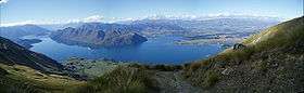
Roys Peak is a mountain in New Zealand,[1] standing between Wanaka and Glendhu Bay. It offers a full-day walk, with views across Lake Wanaka and up to the peak of Mount Aspiring/Tititea. The track zigzags steeply up the side of Mount Roy, through thick grass until the ridge to the summit.
See also
References
- ↑ "Place name detail: Roys Peak". New Zealand Gazetteer. Land Information New Zealand. Retrieved 2009-08-05.
This article is issued from
Wikipedia.
The text is licensed under Creative Commons - Attribution - Sharealike.
Additional terms may apply for the media files.