Route 41 (Iceland)
| |
|---|---|
| Reykjanesbraut | |
 Reykjanes Highway in red | |
| Route information | |
| Existed | 1912 – present |
| Major junctions | |
| Northern end | 40 Kringlumýrarbraut |
|
49 Miklabraut 413 Breiðholtsbraut 411 Arnarnesvegur 40 Fjarðarhraun | |
| Western end |
|
| Highway system | |
| National Roads in Iceland | |

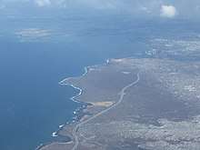
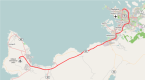
Route 41, known as Reykjanesbraut in Icelandic, is a highway in south-west Iceland, running along the northern shore of Reykjanes Peninsula from Keflavík Airport to the Capital Region.
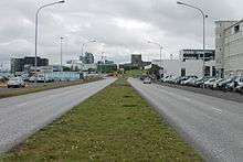
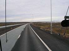
Previously, much of the road was called Keflavíkurvegur but the name is now given to route 424 that runs from Reykjanesbraut through outer Njarðvík and Keflavík. The current road is mostly dual and controlled-access. In addition to being the main road between Reykjavík and Keflavík Airport, it serves as a major traffic artery in the eastern and southern suburbs of the Capital Region. It runs from the intersection of Miklabraut-Sæbraut-Vesturlandsvegur south towards Hafnarfjörður, where it bends, and continues from there to Keflavík. The road was finished in 1912 and was paved in 1965. 2003 saw the start of construction to upgrade the non-urban part to a four-lane road, being completed by October 2008.[1]
Sections
As a national highway the route includes a large part of Sæbraut, a local road in Reykjavík that begins at the northern end of Reykjanesbraut. Therefore, The stretch of Sæbraut east of Kringlumýrarbraut is marked as number 41.
References
- ↑ DV (19 October 2008), Tvöföld Reykjanesbraut komin í gagnið, retrieved 10 April 2010