Route 10 (Hong Kong)
| ||||
|---|---|---|---|---|
| Kong Sham Western Highway, Deep Bay Link/Hong Kong-Shenzhen Western Corridor | ||||
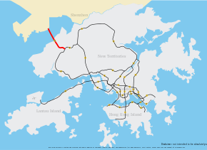 Route 10 coloured red | ||||
| Route information | ||||
| Maintained by Highways Department | ||||
| Length | 10.9 km (6.8 mi) | |||
| Existed | 2007 – present | |||
| Major junctions | ||||
| South end |
| |||
| North end |
| |||
| Location | ||||
| Districts | Shekou, Tuen Mun | |||
| Highway system | ||||
|
Hong Kong Strategic Route and Exit Number System
| ||||

Route 10 is the newest trunk route in the Hong Kong Strategic Route and Exit Number System. It is a 10.9 km dual carriageway with three lanes in each direction, consisting of the Kong Sham Western Highway (formerly Deep Bay Link) and the Hong Kong-Shenzhen Western Corridor, connecting the Yuen Long Highway (Route 9) in Lam Tei to the Shenzhen Bay Port. The trunk route is the only one in Hong Kong that terminates at a border crossing (and is partly built within the area of Shenzhen Municipality).
At one stage, the Hong Kong Government had proposed to build the Yuen Long-Lantau and the Lantau-Hong Kong Island sections of Route 10. While these proposals have since been shelved,[1] an alternative dual carriageway connection between Yuen Long / Tuen Mun and Lantau — the Tuen Mun-Chek Lap Kok Link (connecting the Hong Kong-Zhuhai-Macau Bridge Border Crossing Facilities and North Lantau Highway with Pillar Point near the Tuen Mun River Trade Terminal) and Tuen Mun Western Bypass (starting at Pillar Point and connecting to Route 10 at Tsing Chuen Wai) — has since been put forward. Construction of the Tuen Mun - Chek Lap Kok Link began in 2010 and is scheduled for completion in 2016.[2] As of mid-2010, various alignments[3] for the Tuen Mun Western Bypass were being considered with ongoing consultation with the Yuen Long and Tuen Mun District Councils, Heung Yee Kuk and relevant rural committees.[4]
The 1.6 km section of Route 10 located at north of Hong Kong - Chinese border is also defined as the only part of China G4 Jinggang'ao (Beijing - Hong Kong - Macau) Expressway managed by a region out of mainland China, although it is located in mainland China geographically.
Exit list
| District | Location | km[5] | mi | Exit | Destinations | Notes |
|---|---|---|---|---|---|---|
| Yuen Long | Lam Tei | 0.0– 1.0 | 0.0– 0.62 | 3 | ||
| | 4.2– 5.1 | 2.6– 3.2 | 1 | Ha Tsuen Road | ||
| Deep Bay | 5.3– 11.0 | 3.3– 6.8 | Hong Kong–Shenzhen Western Corridor | |||
| Shenzhen | Shekou | 11.0 | 6.8 | — | Shenzhen Bay Port | |
| 1.000 mi = 1.609 km; 1.000 km = 0.621 mi | ||||||
References and external links
- ↑ http://www.nce.co.uk/objections-force-delay-to-hong-kongs-route-10/812296.article
- ↑ http://www.hyd.gov.hk/eng/major/road/projects/tmclkl_tmwb/index.htm
- ↑ http://www.tmclkl-tmwb.com/en/web/overview/TMWB.htm
- ↑ http://www.tmclkl-tmwb.com/en/web/new.htm
- ↑ OpenStreetMap contributors. Route 10 (Map). OpenStreetMap. Retrieved 27 June 2015.
Coordinates: 22°26′19″N 113°59′07″E / 22.43854°N 113.985339°E