Roundway
| Roundway | |
|---|---|
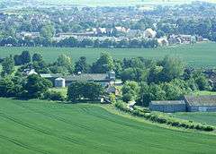 View south from Roundway Hill | |
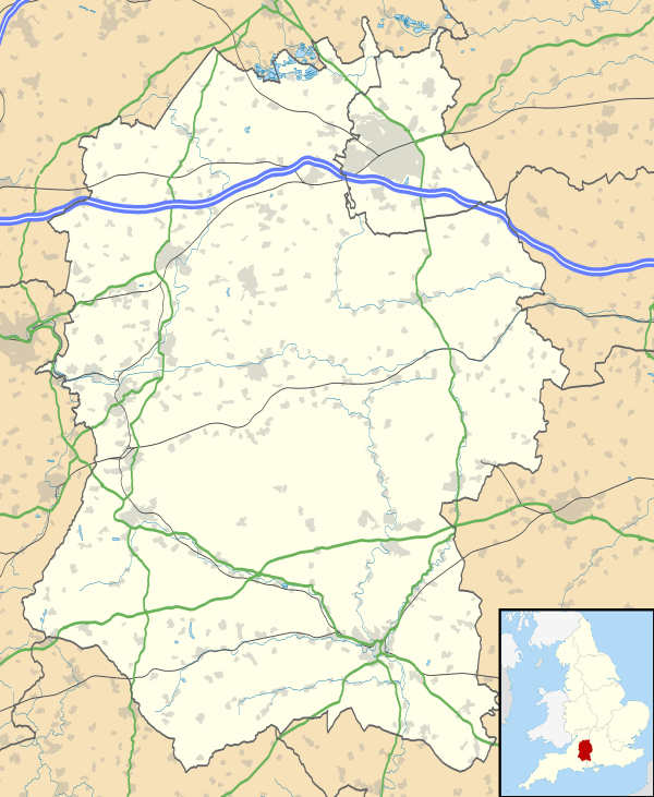 Roundway Roundway shown within Wiltshire | |
| Population | 5,290 (in 2011)[1] |
| OS grid reference | SU014632 |
| Civil parish | |
| Unitary authority | |
| Ceremonial county | |
| Region | |
| Country | England |
| Sovereign state | United Kingdom |
| Post town | Devizes |
| Postcode district | SN10 |
| Dialling code | 01380 |
| Police | Wiltshire |
| Fire | Dorset and Wiltshire |
| Ambulance | South Western |
| EU Parliament | South West England |
| UK Parliament | |
| Website | Parish Council |
Roundway is a hamlet and former civil parish adjacent to Devizes in the English county of Wiltshire.[2] The hamlet lies about 1 1⁄4 miles (2.0 km) northeast of Devizes town centre.
In April 2017, Roundway civil parish was abolished and became a ward of Devizes parish,[3][4] owing to housing development to the north, east and south of the town. In the census of 2001 Roundway parish had a population of 2,267, increasing to 5,290 at the census of 2011.[5]
Roundway ward is located in the north, east and southwest of Devizes, and on the north side lies off the A361, which passes from Devizes to Swindon. On the southwest side it is accessible by the A360 Salisbury – Devizes Road, and by the A342. The small hamlet of Roundway lies just to the north of this, towards the White Horse. The north part of Roundway provides a bypass from the north of Devizes to the west through Conscience Lane.[2]
Towards the south of the ward is the former hamlet of Nursteed, now a contiguous suburb of Devizes.
Most of the land surrounding Roundway is agricultural and to the north of the hamlet is Roundway Hill, a popular place for walking and kite and model aircraft flying. The hill has round barrows which are scheduled monuments.[6]
Governance
The ward elects six councillors to Devizes parish council.[3] It is in the area of Wiltshire Council unitary authority, which is responsible for all significant local government functions.
The civil parish was created in 1894; until then it was part of Bishops Cannings parish in the Potterne and Cannings hundred.[7] Following a community governance review in 2016, Roundway became a ward of Devizes parish; at the same time there were minor boundary changes, so that the Northfields area is wholly within Bishop Cannings parish, while the Hopton industrial estate is wholly within Roundway ward.[3]
An electoral ward with the same name exists. At the 2011 census the population was 4,514.[8]
Amenities
The ward has two primary schools: The Trinity Church of England Voluntary Aided Primary School (to the north) and Nursteed Community Primary School (towards the south).
The Kennet and Avon canal crosses the ward.
Roundway Down and Covert is a Site of Special Scientific Interest.
The ward has no church and is served by churches in Devizes and Bishops Cannings.
Devizes White Horse
A chalk hill figure of a horse was created in the hill above Roundway hamlet in September 1999 to celebrate the millennium. It replaces the white horse of Devizes (Snob's Horse) that was lost after 1845.[9]
Oliver's Castle
Oliver Cromwell fought at the Battle of Roundway Down in 1643, hence the alternative name for the Roundway Downs, 'Olivers Castle'.[2]
Roundway Hospital
A large Victorian psychiatric hospital stood in the south of the parish and served Wiltshire until it was closed in 1995, following a decision to close it in 1989. The mental health services were transferred to the newly built Green Lane hospital in the south of Devizes.[2]
Notable buildings
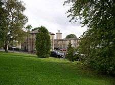
Roundway House, in the north of the ward, is a Grade II listed building that is the remains of the 18th century building in the former Roundway Park.[10] The property was last owned privately by the Colston family who sold it in 1948. It was demolished in 1955 leaving the stable block which was improved and is now used for social functions.
Le Marchant Barracks, on the A361, was used by the army (primarily the Wiltshire Regiment) from 1878 until the 1980s. The keep was converted for residential use in 2013.
Notable people
- Henry Billington, tennis player, born in Roundway; maternal grandfather of tennis player Tim Henman
References
- ↑ "Wiltshire Community History - Census". Wiltshire Council. Retrieved 6 April 2015.
- 1 2 3 4 "Wiltshire Community History - Roundway". Wiltshire Council. Retrieved 9 April 2013.
- 1 2 3 "The Wiltshire Council (Reorganisation of Community Governance) Order 2016" (PDF). Wiltshire Council. 22 December 2016. Retrieved 25 April 2017.
- ↑ Moore, Joanne (31 October 2016). "Two become one in council merger". The Wiltshire Gazette and Herald. Retrieved 10 December 2016.
- ↑ "Parish population 2011". Office for National Statistics. Retrieved 12 March 2015.
- ↑ Historic England. "Roundway Hill Farm round barrows (1004773)". National Heritage List for England. Retrieved 6 April 2015.
- ↑ "Victoria County History - Wiltshire - Vol 7 pp187-197 - Parishes: Bishop's Cannings". British History Online. University of London. Retrieved 6 April 2015.
- ↑ "Ward population 2011". Retrieved 15 March 2015.
- ↑ "Devizes Millenium White Horse". Devizes Heritage. 2013. Archived from the original on 2 May 2013. Retrieved 9 April 2013.
- ↑ Historic England. "Roundway House (1243319)". National Heritage List for England. Retrieved 6 April 2015.
External links
![]()
![]()