Rougemont, North Carolina
| Rougemont, North Carolina | |
|---|---|
| Census-designated place | |
 | |
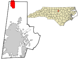 Location in Durham County and the state of North Carolina | |
| Coordinates: 36°13′07″N 78°55′35″W / 36.21861°N 78.92639°WCoordinates: 36°13′07″N 78°55′35″W / 36.21861°N 78.92639°W | |
| Country | United States |
| State | North Carolina |
| County | Durham and Person |
| Area | |
| • Total | 6.4 sq mi (16.5 km2) |
| • Land | 6.3 sq mi (16.3 km2) |
| • Water | 0.08 sq mi (0.2 km2) |
| Elevation | 561 ft (171 m) |
| Population (2010) | |
| • Total | 978 |
| • Density | 156/sq mi (60.1/km2) |
| Time zone | UTC-5 (Eastern (EST)) |
| • Summer (DST) | UTC-4 (EDT) |
| ZIP codes | 27572 |
| FIPS code | 37-58040 |
| GNIS feature ID | 1022403[1] |
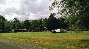
Rougemont[1] is an unincorporated community and census-designated place (CDP) in Durham and Person counties, North Carolina, United States. The population of the CDP was 978 at the 2010 census.[2] An act to incorporate Rougemont as a town was introduced to the North Carolina General Assembly in 2011.[3]
Geography
Rougemont is located in northern Durham County along U.S. Route 501. The center of town is 17 miles (27 km) north of the center of Durham and 13 miles (21 km) south of Roxboro. The CDP extends north into Person County as far as the Flat River, east to Moores Mill Road, south to Quail Roost Farm Road, and west to Harris Road and Chambers Road. The Rougemont ZIP code covers a much larger area, extending west into Orange County and east into Granville County, but all population statistics are for the smaller CDP area.
Points of interest
- Castle Mont Rouge, designed by Robert Mihaly
- Orange County Speedway, 2.5 miles (4.0 km) west of town
References
- 1 2 U.S. Geological Survey Geographic Names Information System: Rougemont, North Carolina
- ↑ "Geographic Identifiers: 2010 Demographic Profile Data (G001): Rougemont CDP, North Carolina". U.S. Census Bureau, American Factfinder. Retrieved December 2, 2015.
- ↑ http://www.ncga.state.nc.us/Sessions/2011/Bills/House/PDF/H292v4.pdf
Municipalities and communities of Durham County, North Carolina, United States | ||
|---|---|---|
| Cities | 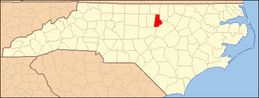 | |
| Towns | ||
| Townships | ||
| CDPs | ||
| Unincorporated communities | ||
| Footnotes | ‡This populated place also has portions in an adjacent county or counties | |
Municipalities and communities of Person County, North Carolina, United States | ||
|---|---|---|
| City |  | |
| CDP | ||
| Unincorporated communities | ||
| Footnotes | ‡This populated place also has portions in an adjacent county or counties | |