Ross-shire
Coordinates: 57°48′N 5°00′W / 57.8°N 5.0°W
| Ross-shire | |
|---|---|
| Historic county | |
 | |
| Country | Scotland |
| County town | Dingwall |
| Area | |
| • Total | 3,089 sq mi (8,000 km2) |
| Ranked 3rd of 34 | |
| Chapman code | ROC (as part of Ross and Cromarty) |
Ross-shire (Scottish Gaelic: Siorrachd Rois) is a historic county in the Scottish Highlands. The county borders Sutherland, Cromartyshire (of which it contains many exclaves), Inverness-shire and an exclave of Nairnshire. It includes most of Ross as well as Lewis in the Outer Hebrides. Dingwall is the traditional county town. The area of Ross-shire was based on that of the historic province of Ross, but with the exclusion of the many exclaves that formed Cromartyshire.[1]
For shreival purposes the area was first separated from the authority of the sheriff of Inverness by Act of Parliament during the reign of James IV, the sheriff to sit at Tain or Dingwall.[2][3] Sheriffs were seldom appointed, and further acts of 1649 and 1661 restated its separation from Inverness.[4][5][3] The 1661 act also clarified the area encompassed, based on the pre-Reformation Diocese of Ross.[5][3] Sir George Mackenzie's Ross-shire estates were transferred to Cromartyshire by a 1685 Act of Parliament (repealed 1686, re-enacted 1690).[1]
The Local Government (Scotland) Act 1889 provided that "the counties of Ross and Cromarty shall cease to be separate counties, and shall be united for all purposes whatsoever, under the name of the county of Ross and Cromarty." The two counties that became the single local government county of Ross and Cromarty, which continued to be used for local government purposes until 1975, although Ross-shire remained as the postal county for the mainland part of the local government county until 1996.
In 1975, Ross and Cromarty was itself replaced by the Highland region and the Western Isles, under the Local Government (Scotland) Act 1973. The region became a unitary council area in 1996, under the Local Government etc. (Scotland) Act 1994.
There was a Ross-shire constituency of the Parliament of Great Britain from 1708 to 1801, and of the Parliament of the United Kingdom from 1801 to 1832. In 1832 it was merged with the Cromartyshire constituency to form the Ross and Cromarty constituency.
Description of the area
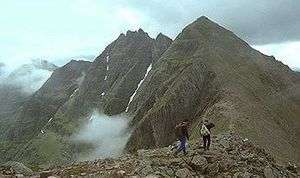
Wester Ross is well known for its mountain scenery, especially the Torridon Hills which includes such peaks as Beinn Eighe and Liathach. Easter Ross is less mountainous, and consists of towns, villages and farmland bordering the Moray Firth. Lewis is the northern part of Lewis and Harris, the largest island of the Western Isles, and is, in general, the lower-lying part of the island. Due to its flatter, more fertile land, Lewis contains three-quarters of the population of the Western Isles, and the largest settlement, Stornoway.
See also
| Wikimedia Commons has media related to Ross and Cromarty. |
References
- 1 2 Mackenzie, Sir George Steuart (1810). General View of the Agriculture of the Counties of Ross and Cromarty: With Observations on the Means of Their Improvement. Richard Phillips. pp. 15–16. Retrieved 28 March 2013. ; RPS 1685/4/66, RPS 1685/4/67, RPS 1686/4/35, RPS 1690/4/108, RPS 1690/4/119
- ↑ RPS A1504/3/105
- 1 2 3 Kennedy, Allan D. (2014-04-03). Governing Gaeldom: The Scottish Highlands and the Restoration State, 1660-1688. BRILL. pp. 155–156. ISBN 9789004269255. Retrieved 24 April 2017.
- ↑ RPS 1649/1/370
- 1 2 RPS 1661/1/197