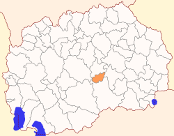
Rosoman Municipality
| Rosoman Municipality Општина Росоман | |||
|---|---|---|---|
| Rural municipality | |||
| |||
 | |||
| Country |
| ||
| Region | Vardar Statistical Region | ||
| Municipal seat | Rosoman | ||
| Government | |||
| • Mayor | Stojanče Lazov (VMRO-DPMNE) | ||
| Area | |||
| • Total | 132.9 km2 (51.3 sq mi) | ||
| Population | |||
| • Total | 4,141 | ||
| • Density | 31.16/km2 (80.7/sq mi) | ||
| Time zone | UTC+1 (CET) | ||
| Area code(s) | 043 | ||
| Website | http://www.OpstinaRosoman.gov.mk | ||
Rosoman (Macedonian: ![]()
Geography
The municipality borders Gradsko Municipality to the north, Negotino Municipality to the east, Čaška Municipality to the west, and Kavadarci Municipality to the south.
Demographics
The municipality has a population of 4,141 according to the last national census in 2002, with density of 31,16 people/km².[1] In the census in 1994, 4,328 people were registered as residents of this municipality. Ethnic groups in the municipality:
- Macedonians = 3,694 (89.2%)
- Serbs = 409 (9.9%)
- others = 38 (0.9%)
Inhabited places
The municipality is completely rural, meaning that all the inhabited places within are villages. There are 10 inhabited places.
| Inhabited places in Rosoman Municipality | ||
|---|---|---|
| Villages: Debrište | Kamen Dol | Kruešvica | Manastirec | Mrzen Oraovec | Palikura | Ribarci | Rosoman | Sirkovo | Trstenik | | ||
References
- ↑ 2002 census results in English and Macedonian (PDF)