Kočani Municipality
| Municipality of Kočani Општина Кочани | |||
|---|---|---|---|
| Urban municipality | |||
| |||
 | |||
| Country |
| ||
| Region | Eastern Statistical Region | ||
| Municipal seat | Kočani | ||
| Government | |||
| • Mayor | Nikolco Ilijev (SDSM) | ||
| Area | |||
| • Total | 375.44 km2 (144.96 sq mi) | ||
| Population | |||
| • Total | 38,092 | ||
| • Density | 105.71/km2 (273.8/sq mi) | ||
| Time zone | UTC+1 (CET) | ||
| Area code(s) | 033 | ||
| car plates | KO | ||
| ISO 3166-2 | MK-42 | ||
| Website | http://www.kocani.gov.mk | ||

Kočani (Macedonian: Кочани [ˈkɔtʃani] (![]()
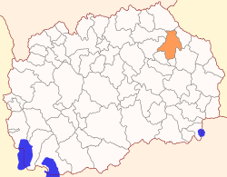
Geography
The municipality borders Kriva Palanka Municipality to the north, Kratovo Municipality and Probištip Municipality to the west, Makedonska Kamenica Municipality and Vinica Municipality to the east, and Češinovo-Obleševo Municipality and Zrnovci Municipality to the south.
History
By the 2003 territorial division of the Republic, the rural Orizari Municipality was attached to Kočani Municipality.
Demographics
There are 38,092 residents of Kočani Municipality, according to the 2002 census.[1] Ethnic groups in the Kočani municipality:
- Macedonians = 35,472 (93.1%)
- Roma = 1,951 (5.1%)
- Turks = 315 (0.8%)
- others.
| Demographics of Kočani Municipality | ||||
|---|---|---|---|---|
| Census year | Population | Territorial Division 2003 | ||
| 1994 | 32,051 | |||
| 38 092 | ||||
| 2002 | 33,689 | |||
| Demographics of the former Orizari Municipality | ||
|---|---|---|
| Census year | Population | |
| 1994 | 4,724 | |
| 2002 | 4,403 | |
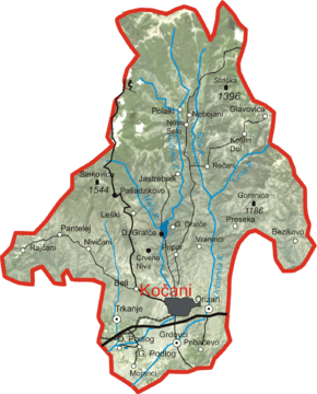
Settlements
| Inhabited places in Kočani Municipality | ||
|---|---|---|
| villages: Bezikovo (Безиково) | Beli (Бели) | Vraninci (Вранинци) | Gorni Podlog (Горни Подлог) | Gorno Gradče (Горно Градче) | Glavovica (Главовица) | Grdovci (Грдовци) | Dolni Podlog (Долни Подлог) | Dolno Gradče (Долно Градче) | Jastrebnik (Јастребник) | Kostin Dol (Костин Дол) | Leški (Лешки) | Mojanci Selo (Мојанци) | Nebojanci (Небојани) | Nivičani (Нивичани) | Novo Selo (Ново Село) | Orizari (Оризари) | Pantelej (Пантелеј) | Pašaďikovo (Пашаџиково) | Polaki (Полаки) | Preseka (Пресека) | Pribačevo (Прибачево) | Pripor (Припор) | Rajčani (Рајчани) | Rečani (Речани) | Trkanje (Тркање) | Crvena Niva (Црвена Нива) |
Town: Kočani (Кочани) | ||
References
- ↑ 2002 census results in English and Macedonian (PDF)
External links
| Wikimedia Commons has media related to Kočani Municipality. |