Roseglen, North Dakota
| Roseglen | |
|---|---|
| Unincorporated community | |
 Roseglen Location within the state of North Dakota  Roseglen Roseglen (the US) | |
| Coordinates: 47°45′5″N 101°50′11″W / 47.75139°N 101.83639°WCoordinates: 47°45′5″N 101°50′11″W / 47.75139°N 101.83639°W | |
| Country | United States |
| State | North Dakota |
| County | McLean |
| Elevation | 2,100 ft (600 m) |
| Time zone | UTC-6 (Central (CST)) |
| • Summer (DST) | UTC-5 (CDT) |
| ZIP codes | 58775 |
| Area code(s) | 701 |
| GNIS feature ID | 1030991 |
Roseglen is an unincorporated community in northwestern McLean County, North Dakota, United States. It lies along North Dakota Highway 37 northwest of the city of Washburn, the county seat of McLean County.[1] Its elevation is 2,100 feet (640 m).[2] Although it is unincorporated, it has a post office, with the ZIP code of 58775.[3] Roseglen Township is served by the White Shield School District, which operates a K-12 public school program from one campus in Roseglen.
External links
References
- ↑ Rand McNally. The Road Atlas '08. Chicago: Rand McNally, 2008, p. 77.
- ↑ U.S. Geological Survey Geographic Names Information System: Roseglen, North Dakota, Geographic Names Information System, 1980-02-13. Accessed 2008-03-31.
- ↑ Zip Code Lookup
Municipalities and communities of McLean County, North Dakota, United States | ||
|---|---|---|
| Cities | 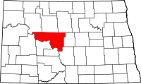 | |
| Townships |
| |
| CDP | ||
| Unorganized territories |
| |
| Unincorporated communities | ||
| Indian reservation | ||
| Footnotes | ‡This populated place also has portions in an adjacent county or counties | |
This article is issued from
Wikipedia.
The text is licensed under Creative Commons - Attribution - Sharealike.
Additional terms may apply for the media files.