Rose Garden, San Jose
| Rose Garden Rosegarden | |
|---|---|
| Neighborhood of San Jose | |
 | |
| Coordinates: 37°18′35″N 121°47′01″W / 37.3096638°N 121.7835622°W | |
| Country | United States |
| State | California |
| County | Santa Clara |
| City | San Jose |
| Zip Codes | 95126 |
Rose Garden, also known as Rosegarden, is a historic residential and cultural neighborhood in San Jose, California, near Downtown San Jose.
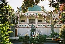
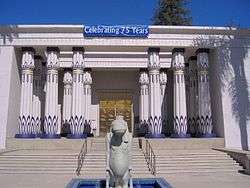
Rose Garden is primarily characterized by historic residences, but it is also home to several cultural institutions, including the San Jose Rose Garden (for which the area is named) and Rosicrucian Park, which includes the Rosicrucian Egyptian Museum
History
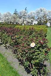
The neighborhood surrounds and is named for the San Jose Municipal Rose Garden, a 5½ acre (22,000 m²) park with thousands of rose bushes.
The Rose Garden is of one of San Jose's oldest neighborhoods outside of the 18th and 19th century downtown core around the Pueblo de San José de Guadalupe. Several existing Victorian houses in the neighborhood date from the 1860s and 1870s, especially along Magnolia Street, Hester Street, and Hedding Street.
One of the oldest subdivisions of San Jose is the 1877 Chapman & Davis tract, which spans roughly 3x8 city blocks lying to the west of the San Jose and Santa Clara Railroad along The Alameda. This was the first interurban railroad in California when it opened with horsecars in 1868, the second electric streetcar line in California (after one in San Diego), and the first interurban electric streetcar in the West when it reopened in 1888 with an underground third rail. It was converted to an overhead trolley in 1889. Each residential lot was originally one-half acre, but most have been subdivided further since.
In the late 19th and early 20th centuries, The Alameda attracted many wealthy residents who built mansions along it. The Dunne mansion on the corner of Emory Street, built in the 1890s, may be the oldest building on the street.
In 1927, what is now the San Jose Municipal Rose Garden and its immediate surroundings were primarily pear and prune orchards, many owned by Food Machinery Corporation (FMC). The area was also home to farm houses and a few mansions. In that year, the City purchased an 11-acre (45,000 m²) prune garden and converted part of it into the Municipal Rose Garden.
In 1937, John Crummey, the chairman of FMC, subdivided his 25-acre (100,000 m²) pear orchard into residential lots sold for $5,00 each. This initial development established the core of the neighborhood called Rose Park.
The neighborhood has preserved its residential housing. The original architecture of the 1920s and 1930s borrowed bits from the English Cotswold Cottage, Norman and Tudor design. Many of the original bungalows have been extensively remodeled or torn down and replaced with newer architectural styles.
Education
High schools:
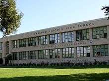
- Lincoln High School - A National Blue Ribbon School - Public
- Bellarmine College Preparatory - Catholic High School
- Downtown College Prep - Charter High School
Middle schools:
- Hoover Middle School - Public 6-8th
Elementary schools:
- St Martin of Tours - Catholic K-8
- Trace Elementary - Public Elementary PK-5th
- Burbank Elementary - Public Elementary
Geography
.jpg)
Located west of Sunol-Midtown, north of Burbank, northeast of Winchester, and east of Cory neighborhood, and southeast of the City of Santa Clara, the Rose Garden can be considered either the easternmost neighborhood of West San Jose, or the westernmost of the central neighborhoods, although being in City Council District 6 and San Jose Unified School District politically ties the area with central San Jose. The basic boundaries are Interstate 880 to the northwest, the Alameda (SR 82) to the northeast, and Forest Avenue to the south, although there are variations.
Santa Clara University lies just to the north/northwest along The Alameda. The College Park neighborhood (including the College Park Caltrain Station and Bellarmine College Preparatory (one of the oldest secondary schools in California) lie to the east. On the south lies the Burbank neighborhood and just a bit West and across Interstate 880, the Cory neighborhood and Valley Fair Mall.
In addition to the Municipal Rose Garden, the neighborhood is home to the Rosicrucian Egyptian Museum, Rosicrucian Park, and O'Connor Hospital.
Notable streets
- The Alameda - Part of California State Route 82, this is the historic El Camino Highway that connects the California Missions from San Diego to San Rafael. The Alameda was the first road that connected the Mission Santa Clara (Ohlone Indians) with the settlement of San Jose (Spanish settlers).
- Morse Street - Named after Santa Clara resident Charles Copeland Morse who founded the Ferry-Morse Seed Company in 1884.
- University Street - Named for the street that was the main entrance to the University of the Pacific (before it moved to Stockton, California and later purchased for Bellarmine College Preparatory. San Jose State maintains their President's home towards the western end of this street.
- Naglee Avenue - Named after General Henry Morris Naglee
- Bascom Avenue - Named after Lewis Hazelton Bascom
- Emory Street - Named after Methodist minister John Emory
- Hedding Street - Named after Methodist minister Elijah Hedding
External links
| Wikimedia Commons has media related to Rose Garden, San Jose. |