Roscoe, Nebraska
| Roscoe, Nebraska | |
|---|---|
| Census-designated place | |
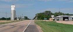 Roscoe, seen from the east along U.S. Highway 30 | |
 Roscoe, Nebraska Location within the state of Nebraska | |
| Coordinates: 41°07′50″N 101°35′09″W / 41.13056°N 101.58583°WCoordinates: 41°07′50″N 101°35′09″W / 41.13056°N 101.58583°W | |
| Country | United States |
| State | Nebraska |
| County | Keith |
| Time zone | UTC-7 (Central (CST)) |
| • Summer (DST) | UTC-6 (CDT) |
| ZIP | 69153 |
| Area code(s) | 308 |
| GNIS feature ID | 832680 |
Roscoe is an unincorporated community and census-designated place in Keith County, Nebraska, United States. Its altitude is 3,173 feet (967 m).[1] Although Roscoe is unincorporated, it has a post office, with ZIP code 69153.
History
Roscoe had its start in the 1870s when the railroad was extended to that point.[2]
References
- ↑ U.S. Geological Survey Geographic Names Information System: Roscoe, Nebraska
- ↑ Burr, George L.; Buck, O. O. (1921). History of Hamilton and Clay Counties, Nebraska. S.J. Clarke Publishing Company. p. 123.
Municipalities and communities of Keith County, Nebraska, United States | ||
|---|---|---|
| City | ||
| Villages | ||
| CDPs | ||
| Unincorporated communities | ||
This article is issued from
Wikipedia.
The text is licensed under Creative Commons - Attribution - Sharealike.
Additional terms may apply for the media files.