Rolling Acres Subdivision
| Rolling Acres subdivision, Pretoria, Ga Rolling Acers | |
|---|---|
| Subdivision | |
| Country | United States |
| State | Georgia |
| County | Dougherty |
| Elevation | 187 ft (57 m) |
| Time zone | UTC-5 (Eastern (EST)) |
| • Summer (DST) | UTC-4 (EDT) |
| ZIP code | 31721 |
| Area code(s) | 229 |
Rolling Acres is a subdivision located in Dougherty County, Georgia.[1]
Geography
Rolling Acres is located within the unincorporated town of Pretoria. It is located off of the Leary Road/Ga Route 62. Rolling Acres is split up into blocks with Hamilton Drive and Oliver Drive running across from each other, Swallow Avenue, Thrasher Avenue, Wren Avenue, Dove Avenue and Lark Avenue run between these two streets. Directly underneath the subdivision is Lonesome Road. Horse Lot Pond lies near, but not in, the subdivision.[1]
References
- 1 2 "Rolling Acres, Georgia GA Community". Georgia Hometown Locator. Retrieved 2011-09-13.
External links
Municipalities and communities of Dougherty County, Georgia, United States | ||
|---|---|---|
| City | 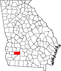 | |
| CDP | ||
| Unincorporated communities | ||
Coordinates: 31°30′14″N 84°19′02″W / 31.5040°N 84.3172°W
This article is issued from
Wikipedia.
The text is licensed under Creative Commons - Attribution - Sharealike.
Additional terms may apply for the media files.