Pretoria, Georgia
| Pretoria, Georgia | |
|---|---|
| Unincorporated community | |
 Pretoria Station | |
 Pretoria Location in Georgia  Pretoria Pretoria (the US) | |
| Coordinates: Community 31°30′15″N 84°19′1″W / 31.50417°N 84.31694°WCoordinates: Community 31°30′15″N 84°19′1″W / 31.50417°N 84.31694°W | |
| Country | United States |
| State | Georgia |
| County | Dougherty |
| Elevation | 187 ft (57 m) |
| Time zone | UTC-5 (Eastern (EST)) |
| • Summer (DST) | UTC-4 (EDT) |
| ZIP code | 31721 |
| Area code(s) | 229 |
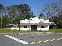
Pretoria is an unincorporated community located in Dougherty County in the U.S. state of Georgia.[1]
Geography
Pretoria's latitude is at 31.504 and its longitude is at -84.317. Its elevation rests at 187 feet. Pretoria appears on the Pretoria U.S. Geological Survey Map.n It rests on the intersections of Tarva Road, Eight Mile Road, and Georgia Highway 62 (Leary Road). Old Pretoria Road, Lonesome Road, Coakly Avenue, Aristedes Road, Slade Avenue, Legget Drive, Vanderbilt Drive and Bluebird Lane also rest in the area. Hunter Lake is the area's largest body of water and the Cooleewahee Creek runs through the town. There are signs welcoming one into the community as well as a 'Dougherty County Work Ready Community Sign'.
Schools
Pretoria has one school called Sherwood Christian Academy. This school is a private school which teaches grades 6-12. The lower campus is located in Albany, Georgia. Sherwood owns legacy park, a large sports complex most notable for its large cross. Sherwood Christian Academy is affiliated with Sherwood Baptist Church of Albany, Georgia, which is well known for its productions Facing the Giants and Fireproof.
Subdivisions
References
- ↑ "Pretoria, Georgia GA Community". Georgia Hometown Locator. Retrieved 2011-06-04.
External links
Municipalities and communities of Dougherty County, Georgia, United States | ||
|---|---|---|
| City | 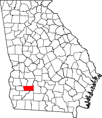 | |
| CDP | ||
| Unincorporated communities | ||