Rogart railway station
| Rogart | |
|---|---|
| Scottish Gaelic: Sgìre Raoird[1] | |
 | |
| Location | |
| Place | Rogart |
| Local authority | Highland |
| Coordinates | 57°59′19″N 4°09′30″W / 57.9886°N 4.1584°WCoordinates: 57°59′19″N 4°09′30″W / 57.9886°N 4.1584°W |
| Grid reference | NC724019 |
| Operations | |
| Station code | ROG |
| Managed by | Abellio ScotRail |
| Number of platforms | 2 |
|
Live arrivals/departures, station information and onward connections from National Rail Enquiries | |
| Annual rail passenger usage* | |
| 2012/13 |
|
| 2013/14 |
|
| 2014/15 |
|
| 2015/16 |
|
| 2016/17 |
|
| History | |
| Original company | Sutherland Railway |
| Pre-grouping | Highland Railway |
| Post-grouping |
London, Midland and Scottish Railway British Railways |
| 13 July 1868 | Opened as Rogart |
| 13 June 1960 | Closed |
| 6 March 1961 | Reopened |
| 12 June 1961 | Renamed Rogart Halt |
| ? | Renamed Rogart |
| National Rail – UK railway stations | |
| * Annual estimated passenger usage based on sales of tickets in stated financial year(s) which end or originate at Rogart from Office of Rail and Road statistics. Methodology may vary year on year. | |
|
| |
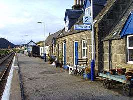
Rogart railway station is a railway station serving the Parish of Rogart and the village of Pittentrail in the Highland council area of Scotland. The station is on the Far North Line. Trains stop on request.
History
The Sutherland Railway opened between Bonar Bridge and Golspie on 13 April 1868.[2] Among the intermediate stations was one at Rogart, which opened with the line.[3] It is 77 miles 1 chain (123.9 km) from Inverness.[4]
In common with six other stations north of Bonar Bridge (now Ardgay), the station at Rogart was closed on 13 June 1960 with the intention of making economies; but the cuts were seen as too drastic, and Rogart station alone was reopened on 6 March 1961.[3][5] Three months later, on 12 June 1961, it was renamed Rogart Halt, but has since reverted to Rogart.[3]
The station has a passing loop 28 chains (560 m) long, flanked by two platforms. That on the down (northbound) line can accommodate trains having five coaches, whereas the up (southbound) platform can hold six.[4]
References
- ↑ Brailsford 2017, Gaelic/English Station Index.
- ↑ Vallance, Clinker & Lambert 1985, p. 35.
- 1 2 3 Butt 1995, p. 199.
- 1 2 Yonge 2007, fig. 20 section B.
- ↑ Vallance, Clinker & Lambert 1985, pp. 161–2.
Sources
| Wikimedia Commons has media related to Rogart railway station. |
- Brailsford, Martyn, ed. (December 2017) [1987]. Railway Track Diagrams 1: Scotland & Isle of Man (6th ed.). Frome: Trackmaps. ISBN 978-0-9549866-9-8.
- Butt, R. V. J. (1995). The Directory of Railway Stations: details every public and private passenger station, halt, platform and stopping place, past and present (1st ed.). Sparkford: Patrick Stephens Ltd. ISBN 978-1-85260-508-7. OCLC 60251199.
- Vallance, H.A.; Clinker, C.R.; Lambert, Anthony J. (1985) [1938]. The Highland Railway (4th ed.). Newton Abbot: David & Charles. ISBN 0-946537-24-0.
- Yonge, John (December 2007) [1987]. Jacobs, Gerald, ed. 1: Scotland & Isle of Man. Railway Track Diagrams (5th ed.). Bradford on Avon: Trackmaps. ISBN 978-0-9549866-3-6.
| Preceding station | Following station | |||
|---|---|---|---|---|
| Lairg | Abellio ScotRail Far North Line |
Golspie | ||
| Historical railways | ||||
| Lairg Line and station open |
Highland Railway Sutherland Railway |
The Mound Line open, station closed | ||