Roebourne, Western Australia
| Roebourne Western Australia | |||||||||
|---|---|---|---|---|---|---|---|---|---|
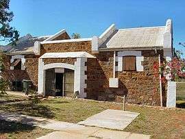 Roebourne Tourist Centre (formerly the entrance to Roebourne Gaol) | |||||||||
 Roebourne | |||||||||
| Coordinates | 20°46′00″S 117°09′00″E / 20.76667°S 117.15000°ECoordinates: 20°46′00″S 117°09′00″E / 20.76667°S 117.15000°E | ||||||||
| Population | 981 (2016 census)[1] | ||||||||
| Established | Proclaimed a township on 17 August 1866 | ||||||||
| Postcode(s) | 6718 | ||||||||
| Elevation | 12 m (39 ft) | ||||||||
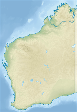
| Location |
| ||||||||
| LGA(s) | City of Karratha | ||||||||
| State electorate(s) | North West | ||||||||
| Federal Division(s) | Durack | ||||||||
| |||||||||
Roebourne /ˈroʊbərn/ is a former gold rush town in Western Australia's Pilbara region. It is 202 km from Port Hedland and 1,563 km from Perth, the state's capital. It prospered during its gold boom of the late 19th century and was once the largest settlement between Darwin and Perth. At the 2016 census, Roebourne and the surrounding area had a population of 981.[1]
History
Roebourne's name honours John Septimus Roe, the first Surveyor General of Western Australia.[2]
The Pilbara region was first explored by Francis Thomas Gregory in 1861. He and his exploration party arrived at the head of Nickol Bay, landing near what was to become Roebourne, and travelling about 60 km inland to present day Millstream Station. Gregory regarded the area as highly suitable for pastoral settlement. The first settlers, including Gregory's cousin Emma Withnell and her young family, arrived in the Roebourne area in 1863. The Withnells established themselves on the banks of the Harding River 13 km from the coast, where they had access to a reasonable fresh water supply, and took up 30,000 acres (120 km²) at the foot of Mount Welcome. In common with many settlers at the time, they hired local Aboriginal people to work on their properties as shepherds, labourers and shearers.
By 1865, the population of the area had grown to about 200, and the Withnells' property served as a local hub, with John Withnell opening a store and providing cartage services to the other settlers. Prior to the construction of a church in the area, services were held in their home.
The Government Resident, Robert John Sholl (1819–86), arrived in November 1865[3] from the failed Camden Harbour settlement (near Kuri Bay) to provide assistance in developing the region and set up camp near the Withnells' home while trying to find a suitable townsite. He eventually decided to locate the town at his camp, and on 17 August 1866, after surveyor Charles Wedge drew a draft plan consisting of 106 lots, Roebourne became the first gazetted town in the North West. It became the region's administrative centre and various government buildings, shops, services and hotels set up business. Sholl himself served as Justice of the Peace, district registrar and magistrate, and he was concerned with the plight of the local indigenous people and made submissions to the Government to ensure they had basic rights.[4]
In 1872, the town was destroyed by a cyclone.[5] Many of the buildings from shortly after this time are heritage listed. A number of the heritage buildings were the work of the eminent Public Works Department architect George Temple-Poole.
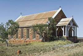 Roebourne, Holy Trinity Church
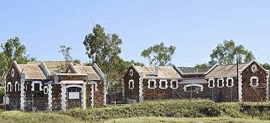 Former Roebourne Gaol by G Temple-Poole
.jpg) Roebourne Courthouse, G Temple Poole (1886)
Roebourne Courthouse, G Temple Poole (1886).jpg) Former Roebourne Shire Offices (1888)
Former Roebourne Shire Offices (1888).jpg) Roebourne Post Office by G Temple-Poole (1887)
Roebourne Post Office by G Temple-Poole (1887)
The site of the Withnells' house, which was rebuilt in 1937 by a later owner, is located on Hampton Street at the foot of Mount Welcome.[6]
Gold from Nullagine, discovered in 1878, and surrounding copper and tin mines contributed to Roebourne's prosperity in the 1880s and 1890s. With the decline of both, Roebourne lost the majority of its European population and became a shadow of its former self. Remnants from that era of prosperity are various National Trust buildings around the town.
The area was struck by another cyclone in 1925 that destroyed the Port Samson jetty and lifted the bridge to Pope's nose from the river bed. Several buildings were also destroyed with the town's residents seeking refuge in public brick buildings during the storm.[7]
Until the 1960s, Roebourne was a non-indigenous town operating as a regional administrative centre, with strict controls and curfews placed on movement of Aboriginal people to, from and within the town. Most Aboriginals were confined to camps and reserves a few kilometres away. However, as mining companies seeking to exploit the iron ore in the region constructed other company towns such as Dampier and Wickham for their workers, and as pastoralism declined, and with changing attitudes to Aboriginal welfare at governmental level in the late 1960s, Roebourne became a majority Aboriginal town as people moved out of the crowded camps and reserves, and from the outlying stations.[8]
In later years, Roebourne became notorious for the struggles between Aboriginals and police that were documented in a federal report dealing with Aboriginal deaths in custody,[9] which were documented as a major issue in Aboriginal affairs from the 1980s onwards. The report showed that Roebourne (with a largely Aboriginal population of 1,200) had ratios of police to citizens that were five times that of towns in more settled parts of Western Australia.
Present day
Currently Roebourne serves the passing highway traffic and tourism, especially as the gateway to many national parks in the interior. The town's education needs are met by the Roebourne School (1905), a K-12 school serving about 250 Aboriginal students. Roebourne also contains a TAFE campus, library and telecentre, as well as a small hospital. Many other services are provided from Karratha, 40 km away.
The area is home to the Ngarluma people, but many Yindjibarndi and Banyjima people previously from outlying stations also live in the town.
Climate
The hottest temperature ever measured in the town was 49.4 °C (120.9 °F) on 21 December 2011.[10]
On 21 December 2011, Roebourne set a new record for the highest maximum temperature recorded in the state during December. The temperature peaked at 49.4 °C (120.9 °F), beating the old record of 48.8 °C (119.8 °F) set at Mardie Station in 1986.[11] Roebourne and the Western Australian town of Carnarvon share the record for Australia's hottest March temperature of 47.8 °C (118.0 °F); it occurred in Roebourne on 4 March 1998 and in Carnarvon on 6 March 2007.[12]
| Climate data for Roeburne, WA | |||||||||||||
|---|---|---|---|---|---|---|---|---|---|---|---|---|---|
| Month | Jan | Feb | Mar | Apr | May | Jun | Jul | Aug | Sep | Oct | Nov | Dec | Year |
| Record high °C (°F) | 49.0 (120.2) |
49.1 (120.4) |
47.8 (118) |
43.4 (110.1) |
39.6 (103.3) |
35.7 (96.3) |
34.8 (94.6) |
37.9 (100.2) |
42.1 (107.8) |
45.9 (114.6) |
47.4 (117.3) |
49.4 (120.9) |
49.4 (120.9) |
| Average high °C (°F) | 38.7 (101.7) |
38.0 (100.4) |
37.6 (99.7) |
35.3 (95.5) |
30.4 (86.7) |
27.0 (80.6) |
26.8 (80.2) |
29.0 (84.2) |
32.6 (90.7) |
35.6 (96.1) |
38.0 (100.4) |
39.0 (102.2) |
34.0 (93.2) |
| Average low °C (°F) | 26.2 (79.2) |
26.2 (79.2) |
25.3 (77.5) |
22.2 (72) |
18.3 (64.9) |
15.3 (59.5) |
13.6 (56.5) |
14.5 (58.1) |
16.8 (62.2) |
19.6 (67.3) |
22.6 (72.7) |
24.9 (76.8) |
20.5 (68.9) |
| Record low °C (°F) | 18.6 (65.5) |
18.3 (64.9) |
16.8 (62.2) |
13.1 (55.6) |
9.4 (48.9) |
7.6 (45.7) |
4.4 (39.9) |
6.4 (43.5) |
7.8 (46) |
11.1 (52) |
14.1 (57.4) |
16.9 (62.4) |
4.4 (39.9) |
| Average precipitation mm (inches) | 59.9 (2.358) |
68.1 (2.681) |
64.4 (2.535) |
28.7 (1.13) |
27.8 (1.094) |
28.8 (1.134) |
13.8 (0.543) |
5.0 (0.197) |
1.4 (0.055) |
0.7 (0.028) |
1.5 (0.059) |
11.0 (0.433) |
311.3 (12.256) |
| Average precipitation days | 3.5 | 4.9 | 3.5 | 1.5 | 2.5 | 2.6 | 1.6 | 0.9 | 0.3 | 0.3 | 0.3 | 1.2 | 23.1 |
| Source: The Bureau of Meteorology[13] | |||||||||||||
See also
Notes
- 1 2 Australian Bureau of Statistics (27 June 2017). "Roebourne (state suburb)". 2016 Census QuickStats. Retrieved 22 January 2018.

- ↑ Western Australian Land Information Authority. "History of country town names – R". Retrieved 2007-01-17.
- ↑ The Inquirer & Commercial News, 10 January 1866, p3.
- ↑ Wendy Birman, 'Sholl, Robert John (1819-1886)', Australian Dictionary of Biography, Volume 6, Melbourne University Press, 1976, pp 121-122.
- ↑ "Country News". The Perth Gazette and West Australian Times. National Library of Australia. 17 May 1872. p. 2. Retrieved 19 October 2013.
- ↑ "Register of Heritage Places – Mount Welcome House, Roebourne" (PDF). 30 October 1998. Archived from the original (PDF) on 2006-08-21. Retrieved 2006-11-19. – includes a broad history of the town of Roebourne.
- ↑ "North-West Cyclone". The Argus. Melbourne, Victoria: National Library of Australia. 4 February 1925. p. 17. Retrieved 21 September 2013.
- ↑ Centre for Aboriginal Economic Policy Research, ANU. "Working Paper 24/2004 – Early Indigenous engagement with mining in the Pilbara" (PDF). p. 3. Retrieved 2006-11-19.
- ↑ "Report of the Inquiry into the death of John Peter Pat". Royal Commission into Aboriginal Deaths in Custody. 15 April 1991. Retrieved 2015-09-29. An additional, less detailed report can be found for Ginger Samson at the same site.
- ↑ "Roebourne". Monthly climate statistics: All years of record. Bureau of Meteorology. 19 March 2012. Retrieved 19 March 2012.
- ↑ Dutschke, Brett (22 December 2011). "WA sets new heat record". Weatherzone. Retrieved 22 December 2011.
- ↑ Bureau of Meteorology (21 March 2013). "Daily Extremes". Australian daily extremes tables. Commonwealth of Australia. Retrieved 29 April 2014.
- ↑ "Climate Statistics for Roeburne, WA". Retrieved 17 January 2012.
Further reading
- Withnell-Taylor, Nancy E. (2002) [1987]. Yeeramukadoo: A saga of the Northwest (The first settlement of north-west Australia told through the Withnell and Hancock families 1861-1890) (reprint ed.). Carlisle, WA: Hesperian Press. ISBN 0-85905-097-1. (254 pages)
- De La Rue, Kathy (1979). Pearl shell and pastures : the story of Cossack and Roebourne. Roebourne, WA: Cossack Project Committees. (134 pages)
- Edmunds, Mary (1989). They get heaps: A study of attitudes in Roebourne, Western Australia. Canberra: Aboriginal Studies Press. (179 pages)
External links
![]()