Rocky Mount-Wilson CSA
| Golden East Metro | |
|---|---|
| CSA | |
| Rocky Mount-Wilson Combined Statistical Area | |
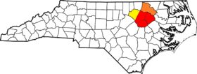 Counties most commonly associated with RM-WI CSA are in red, counties sometimes included are in orange, and counties in yellow are also but rarely included in the CSA | |
| Country |
|
| State |
|
| Principal cities |
- Rocky Mount - Wilson - Roanoke Rapids - Tarboro |
| Area | |
| • CSA | 2,650 sq mi (6,900 km2) |
| • Land | 2,633 sq mi (6,820 km2) |
| • Water | 15.3 sq mi (40 km2) |
| • Urban | 4,313 sq mi (11,170 km2) |
| • Urban land | 4,276 sq mi (11,070 km2) |
| • Urban water | 23.3 sq mi (60 km2) |
| Population (2014 Census estimate) | |
| • Density | 650/sq mi (4,954/km2) |
| • Urban | 311,212 |
| • Metro | 348,137 |
| • CSA | 351,219 |
| Time zone | EST |
| • Summer (DST) | EDT |
| Area code(s) | 252, 919 |
The Rocky Mount-Wilson Combined Statistical Area, as defined by the United States Census Bureau, is in Wilson, Nash, Edgecombe, Halifax, and Franklin counties of North Carolina. It has a population of 348,137. As of 2014 the Rocky Mount-Wilson CSA is the fifth-largest CSA In North Carolina. Boosters refer to it as the "Golden East Metro Area".
Rocky Mount is also a part of the Raleigh-Durham-Cary CSA, with a population of 2,132,523
Largest cities
- Rocky Mount
- Wilson
- Wake Forest (Partially)
- Roanoke Rapids
Counties
Higher education
Largest Cities
- Rocky Mount 58,293
- Wilson 50,113
- Roanoke Rapids 15,623
- Tarboro 11,348
Largest Towns
- Wake Forest 34,752
- Nashville 5,503
- Louisburg 3,512
Places with more than 1,000 to 5,000 inhabitants
Places with 500 to 1,000 inhabitants
- Bailey, North Carolina
- Dortches, North Carolina
- Middlesex, North Carolina
- Princeville, North Carolina
- Whitakers, North Carolina
- Black Creek, North Carolina
- Lucama, North Carolina
- Stantonsburg, North Carolina
- Littleton, North Carolina
Places with less than 500 inhabitants
- Macclesfield, North Carolina
- Leggett, North Carolina
- Speed, North Carolina
- Momeyer, North Carolina
- Conetoe, North Carolina
- Castalia, North Carolina
- Saratoga, North Carolina
- Sims, North Carolina
- Halifax, North Carolina
- Hobgood, North Carolina
- Centerville
- Bunn
census-designated places
- Hollister, North Carolina
- South Rosemary, North Carolina
- South Weldon, North Carolina
Unincorporated places
- Crisp, North Carolina
- Montclair, North Carolina
- Aurelian Springs, North Carolina
- Heathsville, North Carolina
- Brinkleyville, North Carolina
Combined Statistical Area
The Rocky Mount-Wilson Combined Statistical Area is made up of four counties in North Carolina. The statistical area includes the Rocky Mount Metropolitan Statistical Area and the Wilson Micropolitan Statistical Area.
See also
References
^ "Table 1. Annual Estimates of the Population of Metropolitan and Micropolitan Statistical Areas: April 1, 2000 to July 1, 2009 (CBSA-EST2009-01)" (CSV). 2009 Population Estimates. United States Census Bureau, Population Division. 2010-03-23. Retrieved 2010-03-24. ^ "American FactFinder". United States Census Bureau. Retrieved 2008-01-31.