Rocksdale, West Virginia
| Rocksdale, West Virginia | |
|---|---|
| Unincorporated community | |
 Rocksdale  Rocksdale | |
| Coordinates: 38°50′41″N 81°13′05″W / 38.84472°N 81.21806°WCoordinates: 38°50′41″N 81°13′05″W / 38.84472°N 81.21806°W | |
| Country | United States |
| State | West Virginia |
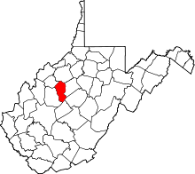
| County | Calhoun |
| Elevation | 676 ft (206 m) |
| Time zone | UTC-5 (Eastern (EST)) |
| • Summer (DST) | UTC-4 (EDT) |
| Area code(s) | 304 & 681 |
| GNIS feature ID | 1555509[1] |
Rocksdale is an unincorporated community in Calhoun County, West Virginia, United States. Rocksdale is located along County Route 9 at the confluence of the Henry Fork and the West Fork Little Kanawha River, site of now closed post office established in late 1800s with a country store.7.5 miles (12.1 km) east-northeast of Spencer.[2]
The community takes its name from a rock formations near the site.[3]
References
- ↑ U.S. Geological Survey Geographic Names Information System: Rocksdale, West Virginia
- ↑ Calhoun County, West Virginia General Highway Map (PDF) (Map). West Virginia Department of Transportation. 2011. p. 1. Archived from the original (PDF) on 2012-04-25. Retrieved October 12, 2011.
- ↑ Kenny, Hamill (1945). West Virginia Place Names: Their Origin and Meaning, Including the Nomenclature of the Streams and Mountains. Piedmont, WV: The Place Name Press. p. 537.
This article is issued from
Wikipedia.
The text is licensed under Creative Commons - Attribution - Sharealike.
Additional terms may apply for the media files.