Rocca la Meja
| Rocca la Meja | |
|---|---|
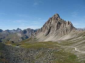 Rocca la Meja seen from Colle d'Ancoccia | |
| Highest point | |
| Elevation | 2,831 m (9,288 ft) |
| Listing | Alpine mountains 2500-2999 m |
| Coordinates | 44°25′N 07°20′E / 44.417°N 7.333°E |
| Geography | |
| Location | Piedmont, Italy |
| Parent range | Cottian Alps |
| Climbing | |
| First ascent | September 17, 1895 by G. Bobba |
Rocca la Meja is a mountain in the Cottian Alps, in the comune of Canosio, Piedmont, northern Italy. It has an altitude of 2,831 m and it is located in the Maira Valley.
Of pyramidal shape, it is mostly composed of dolostone-like limestone, and stands in a plateau known as Meja-Gardetta.
Geography
Administratively the mountain belongs to the Province of Cuneo.
Nearby there is a lake called Lago della Meja.
SOIUSA classification
According to the SOIUSA (International Standardized Mountain Subdivision of the Alps) the mountain can be classified in the following way:[1]
- main part = Western Alps
- major sector = South Western Alps
- section = Cottian Alps
- subsection = southern Cottian Alps
- supergroup = Catena Chambeyron-Mongioia-Marchisa
- group = gruppo Gruppo dell'Oserot
- subgroup = Gruppo della Meja
- code = I/A-4.I-A.2.b
References
This article is issued from
Wikipedia.
The text is licensed under Creative Commons - Attribution - Sharealike.
Additional terms may apply for the media files.