Roaring River (Missouri)
| Roaring River | |
| River | |
| Country | United States |
|---|---|
| State | Missouri |
| Region | Ozark Plateau |
| Source | Roaring River Spring |
| - coordinates | 36°38′38″N 93°48′32″W / 36.64389°N 93.80889°W [1] |
| Mouth | White River |
| - coordinates | 36°32′16″N 93°42′59″W / 36.53778°N 93.71639°WCoordinates: 36°32′16″N 93°42′59″W / 36.53778°N 93.71639°W [1] |
| Length | 14.9 mi (24 km) |
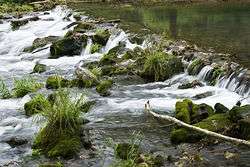
The water rippling over the rocks at Roaring River State Park.
The Roaring River is a 14.9-mile-long (24.0 km)[2] river in Barry County, Missouri, in the Ozarks. It is a tributary of the White River, into which it flows in Eagle Rock, Missouri. This section of the White River is a reservoir called Table Rock Lake.
The stream was named on account of roaring waters from a cave along its course.[3]
See also
References
- 1 2 "Roaring River". Geographic Names Information System. United States Geological Survey. Retrieved 2014-01-26.
- ↑ U.S. Geological Survey. National Hydrography Dataset high-resolution flowline data. The National Map, accessed March 9, 2011
- ↑ "Barry County Place Names, 1928-1945 (archived)". The State Historical Society of Missouri. Archived from the original on 24 June 2016. Retrieved 30 August 2016.
This article is issued from
Wikipedia.
The text is licensed under Creative Commons - Attribution - Sharealike.
Additional terms may apply for the media files.